


0
items
$0
When you dream of your next long walk, there’s no need to wake up disappointed that the Himalayas, Southern Alps or Andes are so far away. Right here in the UK there are a whole host of great long walks, from the easy and accessible (Thames Path) to the challenging and wild (Skye Trail, Cape Wrath Trail).
- Browse our lists of Mountain and Hiking Books / Guidebooks.
- Click here for our list of Top Long Distance Walks in mainland Europe.
So whether you need to walk up the spine of northern England (The Pennine Way), cut England in two walking coast-to-coast (Wainwright’s, Hadrian’s Wall Path or explore Britain’s coasts (South West Coast Trail, West Highland Way) you’ll not need to go as far as you might imagine to experience adventure in your own backyard.
Here, in no particular order, we’ve compiled 8 of the best long distance walks in the UK to get you inspired, out of your armchair and into some great British nature.
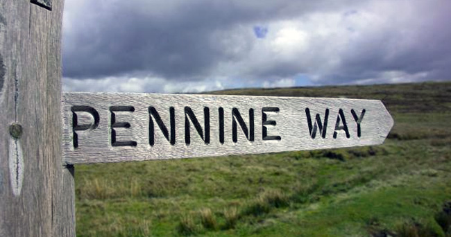
The Pennine Way
From/to: Kirk Yetholm, (Scottish Border) and Edale (Peak District).
Distance: 429 km (268 miles)
Walk time: 16-19 days
When to walk: May-September
Short description: The National Trust’s response to a request for ‘A Long Green Trail’, winding up the spine of northern England.
The National Trust’s first trail, the Pennine Way was opened on 24 April 1965. It was inspired by Tom Stephenson’s 1935 request in an article entitled: Wanted: A Long Green Trail.
Crossing the Peak District, the Yorkshire Dales, North Pennines, Hadrian’s Wall and the Cheviots, the Pennine Way lets you walk straight up the spine of northern England. It was this area that Stephenson had noted that: “restrictions [are] so rigid, and paths so few”.
The route undulates through the three National Parks, two National Nature Reserves and twenty sites of Special Scientific Interest.
This remote and hilly trek is perhaps known for leaving socks wet and hikers happy. Although it has fewer boggy sections than would blight intrepid walkers in the past, the several peat bog traverses that remain are a signature of the route and should be warmly welcomed as a part of its charm.
While most sections are not physically difficult, the first few days of hiking, as well as some sections in the Peak District can be strenuous. If the weather sets in, the hills and muddy ground may seem unending.
Normally walked south to north, following the favourable wind direction, 15,000 walkers with 30,000 soggy socks walk off the trail each year near the Scottish border. You can read the advice of one such walker here.
Hadrian’s Wall Path
From/to: Wallsend (near Newcastle) and Bowness-on-Solway (west coast)
Distance: 135 km (84 miles)
Walk time: 6-7 days
When to walk: May-September
Short description: Combine history with adventure with this coast-to-coast trek along the World Heritage Site of Hadrian’s Wall.
Dissecting the country east-to-west near the border with Scotland, Hadrian’s Wall Path passes through two vibrant modern cities and some of northern England’s most beautiful, rolling countryside.
Whether you choose to get your head down and walk the length of the path in one go, or break it up with visits to historic Roman sites en route, this path provides adventure and intrigue for enthusiasts of all sorts.
Hadrian’s Wall was built as a fortification ‘to separate the Romans from the barbarians’ in 122 AD, and was named after the 14th Emperor of the Roman Empire. The wall had armed forts built every 8 km (5 miles), yet also had gates that are believed to have acted as customs posts, keeping them in absolute control of the border.
Anyone of reasonable fitness should be able to complete this easy-to-follow route—you just follow the wall from one end to the other! But don’t be fooled, this isn’t an easy walk. Rising from the coast to the high central region, and then descending to the sea once more, this walk gains some serious elevation during its 135 km (84 miles).
It is normally walked from east to west, with the most difficult section a series of undulating switchbacks between Chollerford and Birdoswald (37 km/ 23 miles). You can read an account of someone who completed this trail here.
South West Coast Path
From/to: Minehead (Somerset) and Poole Harbour (Dorset)
Distance: 1,014 km (630 miles)
Walk time: 30 days to 8 weeks
When to walk: April-September
Short description: Wrapping the south-west coastline of England, this epic trail keeps the sea in sight throughout a month of hiking.
The National Trust’s longest trail, the South West Coast Path is often enjoyed in shorter sections as you explore the coastline of south-west England. Passing through the counties of Somerset, north Devon, Cornwall, south Devon and Dorset, this trek allows you to visit each and every beach, cliff and coastal town en route.
It was first created by coastguards as a path used to patrol the coast for smugglers. It is also used by fishermen looking for shoals of fish near the shore, and keep check on changeable sea conditions (though presumably not so much these days).
The direction you take the route doesn’t matter, only convention typically describes it as walked anti-clockwise. Whichever direction you choose, the route poses some significant challenges, not least the elevation changes. Some 35,000 m (114,829 ft) of elevation is gained and lost over the course of the route.
But unlike the Pennine Way (see above) a lot of this route passes through small villages and larger towns, so you’ll rarely be too far from the cream teas that are the essential fuel for this challenge.
With excellent access throughout the trail by both road and rail, it is easy to plan your day, multi-day, week or month-long adventure. For a useful breakdown of the route into day-long sections, see this guide from the South West Coast Path team.
Thames Path
From/to: Thames Head (near Cirencester) and Thames Barrier (Woolwich).
Distance: 294 km (184 miles)
Walk time: 14 days
When to walk: April-October
Short description: Trek from the quiet Cotswolds to the heart of cosmopolitan London along this accessible trail.
Meandering through the southern English countryside, the Thames Path is a relatively unchallenging route that follows the path of one of Britain’s favourite rivers. It is often walked from source to flood barrier (west to east), though neither way is particularly harder than the other.
It begins near the town of Cirencester in Gloucestershire, with Oxford a regular marker point. Routes often refer to sections as being upstream and downstream of the ancient university town.
In the sections upstream of Oxford, the landscape is more rural, with populations more spread out. Downstream of Oxford, populations and urban landscapes increase, climaxing, of course, in the bright lights of bustling London.
In winter, sections of the river are prone to flooding, so it’s recommended to take the walk between spring and autumn. With the plethora of river wildlife and wildflowers lining the path, walking this route when it is at its blossoming best appears a favourable option.
Much of the path is also accessible to those with mobility difficulties. Gates are replacing stiles in most places and paths tending to be smooth and maintained, if not actually paved. With plenty of accommodation options en route, this is one long walk that near enough anyone can join in with.
Learn more about the walk divided into relevant sections here, in this example walking away from the city,
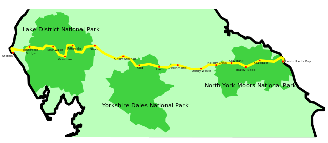
Wainwright’s Coast to Coast Walk
From/to: St Bees (Cumbria) and Robin Hood’s Bay (Yorkshire)
Distance: 305 km (190 miles)
Walk time: 15 days
When to walk: April-October
Short description: Once ranked the second best walk in the world, this northern England gem was the creation of a man who truly loved this landscape.
Alfred Wainwright created the Coast to Coast Walk in 1973, planning an west-to-east trail that passes through the Lake District, Yorkshire Dales and the North York Moors National Parks.
According to a survey of experts in Country Walking magazine in 2004, it was ranked as the second best walk in the world behind the Milford track in New Zealand. It is in the process of being recommended for an upgrade to the status of a National Trail, which is perhaps a little overdue.
Wainwright was known for his hand-drawn pictorial guides to the Lakeland fells, which acted as inspiration for fell walkers throughout the late 20th Century. The route he created takes in this landscape he was so instrumental in celebrating; you pass many of the rivers, peaks and lakes he must have drawn, as you walk straight across the centre of northern England.
This is far from an easy walk, with every day posing a new challenge but offering an equivalent degree of reward. There are a good number of variations for the route, as well as regular, enforced changes to protect and repair worn-out sections.
Typically, the prevailing wind encourages that it is walked from the west coast to the east coast, meaning the difficult Lake District sections come first. Perhaps better to get them out of the way while still fresh!
From fells to moorland, from open fields to rich mining history, the experience of this long walk is one of variety, as can be read about in this Wainwright walker’s account.
Skye Trail
From/to: Rubbha Hunnish (north) and Broadford (south)
Distance: 128 km (78 miles)
Walk time: 7 days
When to walk: May-July.
Short description: An unofficial trek that requires prior experience and pre-planning but rewards with some of Britain’s most spectacular, rugged scenery.
This traverse of the Isle of Skye off the west coast of Scotland demands a great deal of any walker. With no waymarkers, and sections lacking even a path, the Skye Trail is for experienced walkers only, or one to take on under the care of a professional guide.
The route was first described by David Patterson in 1999 and revised to the current route by Cameron McNeish and Richard Else a few years later. The newer route avoids some of the less inspiring landscape, and also reverses the direction (north to south rather than beginning in the south of the island).
With river crossings, ridgeline traverses, and paths along which fatalities have occurred in the past, the Skye Trail certainly shouldn’t be taken lightly. But some careful pre-planning will mitigate most of the dangers presented.
Walking it in early summer offers the best of the weather and avoids the irritating midges of later summer.
The Skye Trail follows the Trotternish ridge for a couple of early days and also winds through the jagged Cuillin peaks in the south of the island towards the end. History is never far away either, with several deserted 18th Century villages, relics of the Highland Clearances.
Of all the walks listed, this is the one that requires the most expertise, but perhaps offers more rugged landscape than any of the other routes. The route is partly designed to let you witness the island’s diverse wildlife, with seals, puffins and whales all on offer at certain times of year. Coves, cliffs and towering rock formations will keep the superlatives flowing through your post-trip account.
It is typically divided into seven day-long stages. However, walkers are encouraged to take a few detours en route, including visiting the Old Mann of Storr and the summit of The Storr (normally added to day two).
In numerous reviews of those who have hiked the Skye Trail, the only real issue is finding enough variety of superlatives. You can read the thoughts of one such enthused hiker here.
West Highland Way
From/to: Milngavie (south) and Fort William (north)
Distance: 154 km (96 miles)
Walk time: 8 days
When to walk: May-June and September-October.
Short description: Rising from the rolling Campsies to the rugged Highlands, Scotland’s first long-distance route offers the best of the central west coast.
Passing famous Scottish landmarks like Loch Lomond, Ben Lomond, Glencoe and the Devil’s Staircase, the West Highland Way is revered with something akin to a pilgrimage through some of Scotland’s most impressive landscapes.
It was Scotland’s first long-distance route and grows from the gentle serenity of the Campsies to the rugged brilliance of the Highlands. Dotted with lochs and rivers, the changes of landscape and accent will endear you to this journey, lending it that mythical quality the Celtic countries tend to imbue.
The unpredictability of Scottish weather and sections that are unpopulated and very exposed do lead to the potential for periods that challenge your emotional resolve more than physical abilities!
The trail was first opened in October 1980, and was then first run in 1985. The West Highland Way race is now an annual event, and has been finished by over 1,000 runners to date (2016).
For the most part, the trail is flat and doesn’t offer significant physical or navigational challenges (almost the exact opposite of the Skye Trail!). But it is still plenty long enough to leave you satisfied after each day of walking! Given that many sections end in, or near to, towns and villages, taking the route as a series of day hikes is also possible.
Cape Wrath Trail
From/to: Fort William (south) and Cape Wrath (north)
Distance: 357 km (222 miles)
Walk time: 2-3 weeks
When to walk: May-July
Short description: Arguably Britain’s hardest walking challenge, the Cape Wrath Trail will take you through the best of Scotland’s rugged landscape to reach the north-westernmost tip of mainland Britain.
The Cape Wrath Trail typically begins in Fort William, where the West Highland Way ends. Two variants for the first quarter of the route offer a good reason to return and attempt this walk twice!
Listed as Britain’s toughest trail, the route winds through unmarked, wild terrain up to the north-westernmost tip of the mainland. This is a route for experienced hikers and backpackers only, as population, along the route, and therefore readily available help, is scattered and sparse.
David Patterson (also the early pioneer of the Skye Trail) first published a suggested Cape Wrath Trail route in 1996. Many hikers have followed him and suggested their own routes. With almost 10,000 m (32,808 ft) of ascent, this route is equivalent of climbing above Everest (though without the issues of altitude of course!)
The main variants are from Fort William to Morvich, before one route is typically followed from here to the trail’s (and the country's) end.
The Glenfinnan variant is the tougher route, offering some of the ‘most rugged and challenging’ sections of the trail. It begins with an ascent of Cona Glen and on through a pass to Glenfinnan. The Rough Bounds of Knoydart are the toughest parts of all, followed by a final climb that takes you to Morvich.
The Great Glenn variant is easier, following the Great Glenn Way to Glen Garry and then onto Glen Loyne and Morvich.
From here, it is forest, sea lochs and coastline, ridge lines, passes and waterfalls to finally, gladly, reach the lighthouse of Cape Wrath.
Camping is recommended, or the use of bothies along the route. As mentioned, the route is completely unmarked, so good navigation skills are also needed, or the assistance of a professional guide.
An account of one Cape Wrath hiker can be read here.

LATEST BLOG POSTS
I quit the rat-race to live a more adventurous life. This is my journey.