


0
items
$0
Across Europe, a network of trails and routes are painted on rocks, trees and paths. They lead you up, over, around and across mountains, ranges and countries, through some of the continent’s most impressive landscapes.
From an ancient pilgrimage to numerous modern Grande Randonnees, Europe offers any number of walks to suit the challenge you may be longing for on your next long distance walk. Here, we list five of the best of them to spark your imagination!
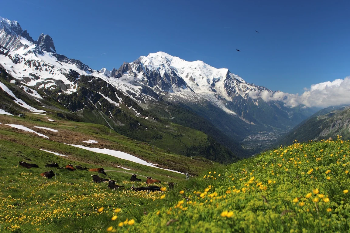
Tour du Mont Blanc (The Alps)
From/to: A circuit with multiple starting points.
Distance: 170 km (106 miles)
Walk time: 7-11 days
When to walk: Year-round, peak season is May-September
Short description: One of the world’s most walked trails (and one of the best served) this three-country circuit of Western Europe’s premier peak is a varied, accessible and challenging adventure.
As a circuit with numerous towns and villages dotted along the route, the Tour of Mont Blanc (TMB) can begin almost wherever you wish to start it. It passes through France, Italy and Switzerland, passing through easy-to-get-to towns such as Chamonix, Courmayer and Champex. And all the while, the Mont Blanc Massif stands at its centre.
Whichever direction you choose to head (clockwise and anti-clockwise), there is a well-defined Normal Route, with optional variants along the way.
The normal route is 170 km (106 miles), and while the variants often reduce distance, they increase the difficulty. The variant between Champex-Col de Balme to the Fenêtre d’Arpette is a particularly challenging option, taking in the TMB’s highest point (2,665 m/ 8,743 ft).
Except for significant steep descents into Courmayer and after Col de Balme (2,191 m/ 7,188 ft), where it would be recommended to save your knees and take a gondola, the route stays high. As such views are rarely anything but spectacular, as you walk over hills and the tops of valleys in the shadow of numerous, snowy peaks.
Over the course of the 7-11 days of walking (depending on route, rest days and accommodation), you’ll get to experience some serious ascents and descents—even some occasional ladders—as you gain and lose 10 km (6 miles) in elevation. All happens under the gaze of fearless ibex and other mountain wildlife and to the tune of ringing Swiss cow bells and many, varied foreign accents.
As a popular hike (with around 10,000 hikers per year), you might expect this to be overly crowded. But not so.
Outside of August (when trails do get more crowded), you can walk this popular route and still find a degree of solitude. The refuges get busy throughout the summer season, but as the route is long and varied enough you can still find plenty of peace, or equally join some companions to encourage you up the tougher hills.
Along the route, there are some fantastic refuges, as well as easy camping spots. This helps make the hike accessible to a wider range of hikers. You can complete the hike as a refuge-to-refuge tour, taking as long as you wish to get from point A to wherever, without needing to carry a tent or cooking gear with you.
The food is usually excellent in the refuges, and beds are of good quality. Some highlights would be: the Refuge de La Croix de Bonhomme with its extraordinary views; the Refuge du Lac Blanc, next to a crystal clear mountain lake in view of Mont Blanc; and Refugio Bonatti, standing over a valley and remote enough that it is resupplied by helicopter!
Information is very easy to come by for this hike—it even has its own app! The TMB allows you to see the route, book refuges and receive up-to-date information on trail conditions and the weather.
A fuller account of the hike can be read here.
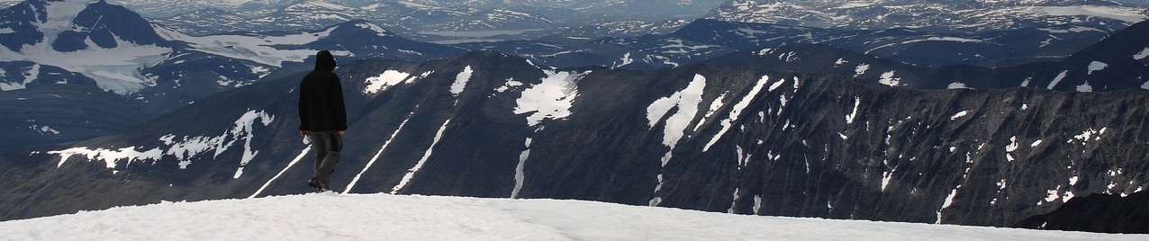
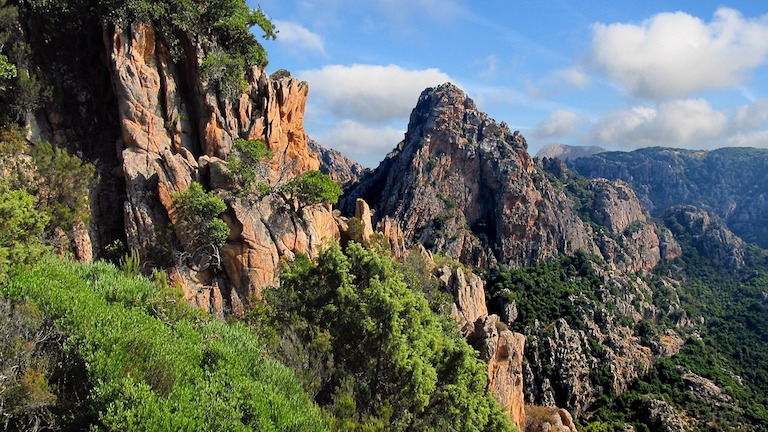
GR20 (Corsica)
From/to: Calenzana to Conca, Corsica
Distance: 180 km (112 miles)
Walk time: 15-18 days
When to walk: late June-early September
Short description: One of Europe’s toughest hikes, this mountainous scramble down Corsica’s spine is not for the faint-hearted. But what you achieve in return is worth every bit of effort you left on the mountainside.
GR translates variously as Grande Randonee (French), Grote Routepaden (Dutch), Grande Rota (Portuguese) and Gran Recorrido (Spanish). They all roughly translate in to English as: ‘long walk, route or hike’.
Of the hundred plus routes criss-crossing Europe, the GR20, which traverses Corsica, is considered the toughest of them all.
The route begins in Calenzana in the north-west of the island and winds a pretty direct south-easterly route across the mountain range to Conca on the south-east coast. There are basic refuges along the route, and camping is only permitted close to these.
Traversing the “steepling spine” of this small French island, which feels more like an Italian island, you pass primarily through the protected national park that covers around 40% of the island. As with most GRs, the route is marked with two horizontal rectangles painted along the way, normally red over white.
Despite these markings, the path itself is often not so simple to find and follow, and the very rugged terrain in the northern sections means progress will typically be slow. You’ll find yourself crossing rock, scree and gravel—at times it is more a scramble than a hike.
Heading from north-south, in the first two days the hiker behind this account claims he was “yet to encounter a section of flat path that stretches for more than 10 metres”. With 13 km (8 miles) of cumulative elevation gain, this story won’t have changed much for most of the northern section (at least).
All that said, the GR 20 does not require particular technical expertise or exceptional fitness, just a certain toughness and deep-rooted motivation.
As there are far fewer people on this route and conditions are less modern and luxurious when compared with, say, the TMB, the GR20 becomes as much a mental battle as a physical one.
To alleviate these concerns, decent preparation will be a huge benefit to your experience. This includes knowing where to stay en route, where to obtain clean water and a regular checking of the weather, as storms can be very dangerous here.
So, if it’s so tough and gruelling, why is this hike on our list?
Perhaps for both the reasons the hiker mentioned above asserts: “This is beautiful, but insane.” Walking through this pristine national park and traversing an entire island across the top of its land is a challenge and an opportunity worth every bit of the toil it demands.
Or perhaps simply because it’s on the National Geographic’s Adventure Bucket List, and surely this is all the validation you could ever want.
Camino de Santiago (Spain)
From/to: Various starting points to Santiago de Compostela, north-west Spain.
Distance: 87-1,000 km (54-621 miles)
Walk time: 30-35 days (Camino Frances)
When to walk: April-June or September (best weather)
Short description: The pilgrim’s route is a spiritual journey that draws hikers from across Europe to a Saint’s tomb in the small town of Santiago de Compostela in north-west Spain.
The Camino de Santiago, or the Way of St James, is not one trail but rather a network of historical routes that culminate in the tomb of St James in north-west Spain. The most popular route crosses the Pyrenees from south-west France, but other routes travel from within Spain and Portugal. All routes (almost) lead to the town of Santiago de Compostela.
No route is technically difficult and most are well-marked with yellow arrows or marks resembling the scallop shells of the Compostela (see below). However, the routes are long, ranging from 87-1,000 km (54-621 miles), the longest being the Chemin de Paris and the Via de la Plata.
These routes have an ancient Christian history and were created after the discovery of St James’ tomb in the north-west of Spain in 814 AD. St James was an evangelical apostle of the Iberian Peninsula who died in 44 AD. Many routes fell into disrepair during the middle ages, but saw a resurgence of interest in the late 19th Century and a pilgrimage popularity boom during the second half of the 20th Century.
A Compostela is the accreditation received by anyone who completes the pilgrimage in the proper manner. Traditionally in the shape of a scallop shell, these require completing at least the last 100 km (62 miles) on foot or horseback, collecting a series of official stamps en route and having a religious or spiritual reasons take the walk.
The routes themselves vary greatly, though none of them are particularly challenging, just long. The most popular is the Camino Francés, or the French Way, chosen by around 60% of pilgrims.
It is 769 km (478 miles) long and begins on the north of the Pyrenees in St Jean-Pied-du-Port. The first day involves crossing the Roncesvalles pass through the Pyrenees, which reaches a maximum height of 1,601 m (5,253 ft). This is the hardest single day of the camino, so perhaps it’s good to get out of the way on day one!
There are 13 Camino de Santiago routes in total, including:
• Camino del Norte – a scenic, more solitary route across the north of Spain from Irún (830 km/ 516 miles)
• Via de la Plata – the longest route within Spain begins in Sevilla and runs north along a rarely used but well-marked route, with several towns and cities en route in which to recuperate. (1,000 km/ 621 miles)
• Camino de Finisterre & Muxia – an oddity in the group, this is a route that goes from Santiago de Compostela. Taking you to the westernmost part of continental Europe, historically, this route took you to the edge of the known world! (87 km/ 54 miles)
Haute Randonee Pyreneene (HRP) (Pyrenees)
From/to: Henlaye to Banyuls-sur-Mer, France
Distance: 800 km (497 miles)
Walk time: 23-45 days
When to walk: July-August
Short description: Take the high, unmarked road (well, not even really a trail) from the Atlantic to the Mediterranean sea along one of Europe’s great High Routes. Someone else will take the low road, and have a much less impressive time.
Sandwiched between the GR 10 in southern France and GR 11 in northern Spain, the Haute Route Pyrénéene, or High Route of the Pyrenees (HRP), tracks a route from the Atlantic (west) to the Mediterranean (east).
This grand mountain range divides France from Spain and contains within its peaks the tiny nation of Andorra. On its northern side, the wetter French Pyrenees hosts the GR 10, an older, more popular and slightly shorter route than its southern neighbour, the GR 11 in the Spanish Pyrenees.
In comparison, the HRP stays high and nationally non-committal, wandering across the border at will. It is shorter and has less cumulative elevation gain (still around 4,200 m/ 13,800 ft). However, at this elevation there is often snow on the ground even in mid-summer, and the route cuts through paths chosen as the “highest and most inaccessible”.
With paths rarely marked, navigational skills and experience of hiking at altitude are definitely prerequisites if you are thinking of self-guiding this adventure. With some steep descents, treacherous scree slopes, paper-thin ridge lines and lingering snow, this is certainly a hike for more experienced adventurers.
You’ll also benefit from having some prior technical climbing experience. However, as the route is not pre-defined and simply more of an idea, there should normally be ways to navigate sections that are outside of your technical capabilities.
The rewards the HRP to an intrepid adventurer offers are many and worthwhile.
It has some of the most beautiful views of both sides of the range, allows you to visit places only accessible by foot and gives one of those rare, truly wilderness experiences as an antidote to our modern, urban lives. And often you walk in the company of local livestock, so you’ll never be too lonely!
The broad span of walking times quoted reflects the ranges of experience, pack size and fitness that may attempt the route. Most advice suggests 45 days is typical for someone with a good level of fitness and experience.
Given the remoteness of the route, wild camping is the norm for most of the adventure, and is considered legal and permitted (mostly). Check local regulations when in populated sections however, as there are laws that prohibit camping under certain conditions.
An account of the route can be read here.
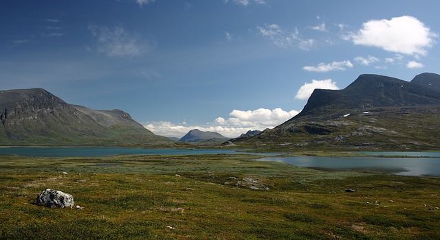
Kungsleden (Sweden)
From/to: Abisko (north) to Hemavan (south), Samiland
Distance: 440km (273 miles)
Walk time: 22-28 days
When to walk: June to late September
Short description: One of Europe’s most remote treks, this other-worldly journey takes you through Sweden’s far north in a place where the epic landscape stays in view late into the night.
Passing mountains, arctic forests, glaciers and one of Europe’s largest protected areas, this is route takes you through Samiland, an historic landscape 200 km (124 miles) within the Arctic Circle.
Kungsleden means ‘the King’s Trail’. It was conceived as part of the efforts to make Sweden’s mountains more accessible in the late 19th Century, eventually opened in 1926.
While not known for its mountains, Swedish Lapland boasts 11 peaks over 2,000 m (6,562 ft) and some deep gorges to match them. Much of Kungsleden passes along the border with Norway, with views of fjords possible off in the distance during sections.
This is largely a well-equipped and maintained trail, with some wooden walkways over difficult or sodden ground, bridges over seasonal streams and boats available at lakes and rivers. Some remote sections are in worse condition, but these are not the more treacherous or difficult sections so pose few genuine issues.
The route is divided into four week-long sections, and is normally walked north-south. There are huts along most of the route, save the 130 km (81 miles) between Kvikkjokk and Ammarnäs when a tent will be required.
In summer, it is light for much of the day, meaning the length of your walking day can be more relaxed than other hikes further south. That’s good, as distances of up to 25 km (16 miles) are required some days. Temperature swings can be significant here, so pack in preparation for this.
The Kungsleden doesn’t need much more than decent physical fitness, but does benefit from some prior experience on long trails. If in doubt, go with one of the many guided tours that are available.
This hikes real value? As this account tells us: “There are few places on Earth [sic] that have the power to make you feel like you are on another planet…[A]mong the mountain trails of the highest peaks of Swedish Samiland is one such place.” That’s enough to convince me

LATEST BLOG POSTS
I quit the rat-race to live a more adventurous life. This is my journey.