
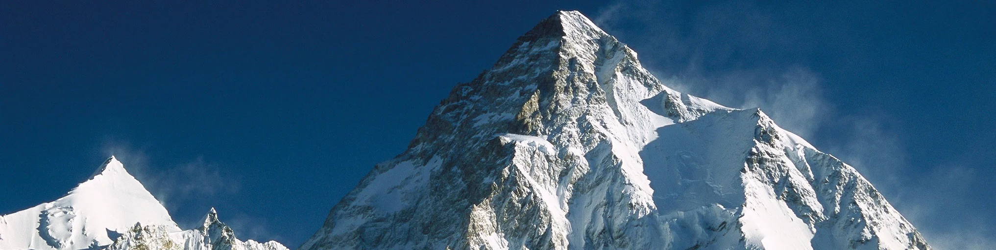
THE MOUNTAIN OF MOUNTAINS, K2 IS ONE OF THE WORLD’S MOST INFAMOUS PEAKS. A JAGGED PEAK OF ICE AND BLACK ROCK, ITS HISTORY RIGHTLY EARNS ITS NICKNAME AS THE SAVAGE MOUNTAIN.
Name: K2 Chhogori (Balti); Godwin-Austen (briefly, British).
Height: 8,611 metres (28,251 ft)
Location: In the Karakoram Range, Kashmir, on the border between Pakistan and China.
First climbed: 1954 (Achille Compagnoni and Lino Lacedelli)
Climb Time: 1 - 2 months
Best Season to Climb: June - August
Introduction to K2
The first man to climb all 14 eight-thousander mountains, Reinhold Messner, called K2 the ‘Mountain of Mountains’. Surrounded by the highest concentration of high peaks in the world, K2 (8,611 m/ 28,251 ft) is the world’s second highest mountain, beaten only by the indomitable Mount Everest (8,848m/ 29,029 ft).
The mountain’s infamy as the ‘Savage Mountain’ – centred around its intense climbing challenges and vicious weather – has inspired many to attempt climbing it, to write about it and even to make Hollywood movies about it.
Jump to Trekking Guide or Climbing Guide
But, statistically, for every four successful ascents, one climber dies. And with only a little over 300 successful ascents, K2 is arguably one of the world’s greatest mountaineering challenges.
History of K2
Since the commercial era of climbing in this region took off in the late 1980s, K2 has been one of its global stars. It even has a couple of Hollywood movies to its name: K2 (1991), starring Michael Biehn and Matt Craven and Vertical Limit (2000), starring Chris O'Donnell and Scott Glenn.
The mountain was first discovered by a westerner in 1856. Colonel T G Montgomerie was performing a survey of India, and assigned the peak the name K2 because it was the second mountain visible to him in the Karakoram Range.
In total, six mountains were given these somewhat uninspired names. In the 1850s, six huge mountains were named from K1-K6, though many have now been renamed (K1 is now called Masherbrum). All of these were visible from Montgomerie’s survey station on Mount Harumukh in Kasmir.
The Godwin-Austen glacier (see below) was named after the first K2 surveyor, Colonel H Godwin-Austen, an English geologist and topographer from the 19th Century.
A History of Climbing on K2
A hugely revered mountain for climbers, K2 is also one of the most challenging.
Severe storms make an already demanding climb even more dangerous, and can trap climbers in high altitude camps longer than is safe (see 1986 K2 disaster below). The technical climbing demanded by K2 at this height is also very difficult – even for the most experienced climbers. As such, the total number of successful summits achieve are far fewer than on Everest and several other eight-thousanders.
Yet, K2 has a long and interesting climbing history, including a number of notable ascents.
The first attempt to climb the mountain was in 1902 by a British chemist called Oscar Eckhenstein and six others. After five failed attempts made during 68 days on the mountain, terrible weather and other issues left him to concede defeat having reached 6,525 m (21,407 ft). His route was not used again for 74 years.
A renowned Italian, the Duke of Abruzzi also made an attempt on K2 to reach the summit. The Standard route, the Abruzzi Spur, is named after him. He took the south-east route, reaching 6,250 m (20,510 ft) before the difficulty became too great to continue.
In 1939, Fritz Weissner reached just 229 vertical metres (750 ft) from the summit before turning back. It’s said that the reason was a fear in his companion Sherpa that reaching the summit after dark meant spirits would kill them, so the group retreated out of respect or good judgement! Given the lack of respect some climbers show for local customs, this story is a credit to Weissner and his team.
A further failed attempt on reaching the summit was made in 1953 by Charles Houston and a team, including Arthur Gilkey. He became the focus of the ascent as he developed blood clots that caused him to need to be lowered down the mountain. A number of near disasters finally reached their somewhat inevitable ending, as Gilkey was swept off the mountain in an avalanche. His remains were not discovered for another 40 years.
In total, 80 people have died on these slopes, 13 in the 1986 season alone. This gives K2 a death rate (summit success/deaths) of around 25 %, one of the highest ratings in the world.
GEOGRAPHY of K2
Located in the north-western Karakoram mountain range, K2 is located between Baltistan and Xinjiang, China. As a glacier and snow-covered, pyramidal mountain, it rises abruptly from its base at approximately 4,500 m (14,764 ft) to its towering summit at 8,611 m (28,251 ft).
Its prominence, among this consistently high region, is only the 22nd largest in the world. In fact, such is the regions elevation, it is possible to walk a path between K2 and Everest that never drops below 4,594 m (15,072 ft).
K2 hosts a number of glaciers, most notably the Godwin-Austen glacier (or Concordia) to the south and the Qogir/K2 glacier to the north. The Godwin-Austen glacier feeds the enormous Baltoro glacier, its name a relic of an early British exploration. In fact, K2, for a time, the British knew the mountain as Mount Godwin-Austen, though the name clearly never stuck.
The Baltoro Glacier, found near the base of K2, is the 5th longest glacier in the world outside the Polar Regions, stretching around 67 km (42 miles) with a very wide trough.
The First Ascent of K2
Two Italians completed the first successful ascent of K2 on the 31 July 1954: Achille Compagnoni and Lino Lacedelli.
The team who reached the summit in 1954 was supported by several Italian organisations including the National Research Council, Military Geographic Institute, Italian Government and the Italian Alpine Club, and was led by Ardito Desio, a renowned explorer and geologist. Desio had previously coordinated a successful expedition in the wider Karakorum area, conducting the very first topographical surveys there and completing a variety of geographic and geological surveys of unexplored areas.
The climbing team included thirteen climbers and five researchers, alongside a number of porters from Pakistan. The group followed the Abruzzi Spur route on the south-east of the mountain. A total of nine camps were set up along the route as well as fixed ropes along much of the route. One of the group, guide Mario Puchoz, died in Camp II because of pneumonia, which became a fatal pulmonary oedema.
Two members of the group, Amir Mahdi and Walter Bonnati, were instrumental in the final success of the expedition, though stories conflict as to how.
One version, which has growing credibility, says that they sacrificed their own safety to transport oxygen tanks to the summit climbers, who ran out of oxygen 150 m (500 ft) below the summit. Another version says that they were to blame for using up the oxygen lower down, forcing the summit party to climb the last section without oxygen.
Either way, when Compagnino and Lacedelli reached the summit, the climbers stationed at Camp VII observed Campagnoni and Lacedelli plant an ice axe featuring both the Italian and Pakistani flags.
The first woman to reach the summit was Polish climber, Wanda Rutkiewicz in 1986. Later that same year two other women also reached the summit: French climber Lilian Barrard (late June) and British climber Julie Tullis (early August).
However, both these climbers perished during their descents. Tullis died during a brutal period blighted by terrible weather and a lack of resources. Known as the 1986 K2 disaster, five climbers died within a five-day period. During the the preceding weeks 1986 climbing season, eight others died, including Barrard.
Another high profile victim of K2 was Alison Hargreaves, who died in 1995, descending from the summit in a violent storm.
Difficulties of climbing Guide to K2
Technical climbing.
The amount of technical skills required by climbers on K2 is significant. The terrain includes ice and limestone, with slopes of 45º or more. Climbers also have to fix up to 2,500 m (8,200 ft) of ropes on the southern route and up to 5,000 m (16,400 ft) on the North Ridge route.
Altitude dangers.
Altitude sickness, and pulmonary and cerebral oedema are significant risks on K2. Health deteriorates quickly at these altitudes; even the healthiest climbers can be caught out by K2’s weather trap (see below).
Before 2004, many climbers didn’t climb with supplementary oxygen. While far from recommended, these climbers, if successful, must have spent a significant period of time acclimatising to the elevation.
Weather risk.
One of the primary reasons for the dangers attributed to altitude on K2 is the unstable weather, which can trap climbers at high altitude camps for long periods. The weather is more severe on K2 than the surrounding peaks as it stands far above them, exaggerated by its slopes that are much more exposed than other eight-thousander peaks.
Typically, windows of good weather last little more than two days, so it is unlikely that a climber can summit the mountain without spending some period trapped by adverse weather. This makes planning very difficult.
Go it alone.
Porters rarely accompany climbers high on the routes so all equipment carrying and camp set-up has to be completed by the climbers themselves. This adds a significant work load and carry weight to bodies that are perhaps less accustomed to the demands of such altitude.
TREKKING AROUND K2 & CONCORDIA
The Concordia region, found at the confluence of the great Baltoro glacier, offers the best opportunities for trekking, wilderness camping and walking in the vicinity of K2. The region is considered to be among the world's best areas for trekking given the landscape with a backdrop with the likes of K2, Broad Peak and Gasherbrum.
The K2 Base Camp trek is perhaps one of the most amazing treks that you can participate in. Adventurers begin in Skardu, Pakistan to the south of the Karakoram Mountains before being transported by Jeep to Askole. This trek normally runs over 21-24 days.
The route follows a path through rugged mountains up to Concordia. Trekkers then follow a route north up the Baltoro glacier to take in sights such as the Trango Towers, Broad Peak and K2.
Another trek is the K2 and Gondogoro La Pass trek, which offers more of a climbing challenge. This route is perfect for adventurers who love the outdoors and a physical challenge without needing to go up to high altitude.
Climbers spend time at the Broad Peak Base Camps and K2 before commencing the challenging trek out over the Gondogoro La Pass. Trekkers then descend into the Hushe valley.
Climbing Routes on K2
K2 can be climbed from both Pakistan and China, with the most popular route being the Abruzzi Spur. All routes pose significant dangers, with avalanches and technical climbing wherever you go.
Routes from the Pakistan side of K2:
Abruzzi Spur/South-east Ridge.
This is considered the Standard route on K2, yet it is still a dangerous and challenging journey. Falling rocks from higher on the mountain are one of its unusual dangers.
The route begins at the K2 Base Camp, reached from Concordia in the south. An initial 1,000 m (3,280 ft) of steep climbing over loose scree welcomes the climbers to the mountain, laying a marker for the difficulties to come.
Camp I is reached at 6,050 m (19,849 ft), while Camp II is found at 6,700 m (21,982 ft). The route between these camps includes the famous House Chimney, a 50 m (164 ft) wide crevasse littered with old ropes from previous expeditions.
During the section between Camp II and Camp III (7,200 m/ 23,622 ft), climbers meet the Black Pyramid – a 400 m (1,312 ft) sequence of the most technical vertical climbing found on K2, navigating both rock and ice. Camp III is dangerous as it has a high risk of avalanches and exposure to the high winds in a wind tunnel between Broad Peak and K2.
Between Camp III and Camp IV, the terrain becomes slow, strenuous and difficult to navigate because of the depth of snow cover. However, swift progress is required here as there is very high avalanche risk, and even reports of sections of the shoulder collapsing onto the route.
Camp IV, at 7,600 m (24,934 ft), is still a further 16-22 hours from the summit. As such, the majority of climbers will need to leave camp anywhere between 10pm and 1am to be successful (and safe) within daylight hours on their summit day.
North-east Ridge.
The North-east Ridge was first climbed by an American team including John Roskelly, Rick Ridgeway, Jim Wickwire and Lou Reichardt in 1978.
This route takes climbers up a lengthy, snow-covered rib beginning at the top of the Godwin-Austen glacier and includes the navigation of a tough, corniced ridge. At 7,900 m (25,919 ft), the route passes over the East Face to join the Abruzzi Spur route to the summit.
The Magic Line/South-west Pillar.
Before his attempt in 1979, Messner referred to this route as The Magic Line. However, once on the mountain he redefined the route as ‘suicidal’ and switched to the Abruzzi Spur.
It was finally opened in 1986, though with the difficulty of the high altitude ice and rock climbing, Messner’s revised nickname remains the best description!
South Face/Polish Route.
Climbers face significant risks from frequent avalanches, particularly in the lower sections of the climb in what is known as the Hockey Stick. We’ll let you figure out why that might be, then hope you choose not to take this needlessly dangerous route!
West Ridge.
Climbers start this route at the Base Camp on the Negrotto Glacier and join the ridge crest at approximately 5,800 m (19,029 ft). One of the main problems that climbers have to overcome is navigating bands of rocks and snowfields while setting fixed lines at high altitudes. This is particularly the case while crossing over the west side.
Routes on the Chinese side of K2.
The routes on this side of the mountain are not used as much as the routes from the Pakistan side of K2, and there are rarely many climbers on this side of the mountain. As such, here are the two primary routes that have so far been opened.
North Ridge.
This route was opened by a Japanese team in 1982 and required the use of approximately 5,000 m (16,404 ft) of fixed lines. It is perhaps the most spectacular route in all of the Karakoram / Himalayas because it covers an extensive ridge that runs all the way from 5,182 m (17,000 ft) right up to the summit.
There are a number of obstacles around this area, particularly when you get to 8,450 m (27,723 ft). The route deviates from the ridge at approximately 7,800 m (25,591 ft) and takes climbers across the North Face to the North East Ridge. Climbing on this route consists predominantly of ice climbing, and fixed ropes are required for much of the route.
Two of the camps used are also tricky. Camp I is set up on Bergschrund, a snow slope with a deep crack that is prone to avalanches. Camp IV is only suitable for 2-person tents, and is known as, perhaps illustratively, the Eagles Nest.
King Traverse route/North-west Face.
This K2 route was opened by a Japanese team in 1990.
Climbers start their journey at the Qogir/K2 Glacier before climbing to the North-west Ridge and cutting across the rocky terrain and snowfields of the North-west Face. The route then joins the North Ridge to the summit.