


0
items
$0
Arguably the world’s greatest range, the mountains of the Himalayas create a landscape of unparalleled adventure in a vast, rugged, high altitude wilderness.
As much an exploration of cultures far from our own, the Himalayas offer far more than the mountains for which they are famous. Here, we explore five of the best long distance walks in the Himalayas, including two trips to mountain base camps, some glacial landscapes and trips to and around the world’s highest and deadliest mountains.
Now, let’s go hiking in the Himalayas!
Everest Base Camp trek (Nepal)
From/to: Lukla to Everest Base Camp (and return)
Distance: 124 km (77 miles) return
Walk time: 11-14 days
When to walk: September to June, quietest December to January
Short description: Climbing to the base of the world’s highest peak, this iconic trek hits many of the Himalayas’ most popular highlights and poses a physical challenge to any who take it on.
Climbing to the base camp where expeditions ascend the world’s highest peak may sound like only half an adventure. But trekking to the Everest Base Camp is a multi-day adventure that won’t feel like a half measure on any count.
Over the course of the trek, you’ll pass by or look up to Mount Everest (8,848 m/ 29,029 ft), Cho Oyu (8,201 m/ 26,906 ft), Lhotse (8,516 m/ 27,940 ft) and Ama Dablam (6,821 m/ 22,349 ft), among others. Winding glaciers, ice-capped summits and a cherished insight into the world’s most famous mountain folk, Sherpas, make this extraordinary in a very true sense of the word.
As with most Nepalese adventures, this trek begins in Kathmandu, followed by a short flight into the airport built by Sir Edmund Hillary in Lukla (2,860 m/ 9,383 ft).
The trek begins by heading up to the village of Phakding (2,610 m/ 8,563 ft), a UNESCO World Heritage Site where you’ll enjoy your first night in a local tea house. Most nights on a Himalayan trek are spent in these, hosted by the local.
Then it’s on to the Sagarmatha National Park (the Nepalese name for Everest) and up the forested Dudh Kosi river valley to the Sherpa capital of Namche Bazaar (3,440 m/ 11,286 ft). Normally, a day is spent here soaking up this new cultural experience and acclimatising to the altitude.
The following two days climb to Dingboche (4,410 m/ 14,469 ft) over an increasingly dry, mountainous terrain. This section offers the first motivating views of the world’s highest peaks, so you’ll barely notice the increasingly steep uphills (maybe!)
The route to Dingboche goes via Tengboche (3,867 m/ 12,687 ft), home to the largest monastery in the Khumbu region with incredible views of Ama Dablam.
After another rest day, its a two trek to the high point and end goal: Everest Base Camp (5,364 m/ 17,598 ft). From Dingboche, the route passes the village of Lobuje (4,931 m/ 16,178 ft) near the twin-peaked mountain of Lobuche (6,119 m/ 21,716 ft) then onto Gorakshep (5,164 m/ 16,942 ft) before finally reaching Everest Base Camp.
Among the sights from Everest Base Camp are the treacherous Khumbu icefall, the dominating face of Lhotse to the south-west of the peak of Mount Everest, and of course the mighty Everest itself.
The trek is then reversed, speeding back to Lukla in only three or four days for a flight back to Kathmandu.
Photo by Dhilung
Makalu Base Camp trek (Nepal)
From/to: Tumlingtar to Makalu Base Camp (and return)
Distance:
Walk time: 18-23 days
When to walk: April-June and September-October
Short description: Undulating through glacial valleys in the shadow of granite ridgelines and cascading waterfalls, this challenging trek leads up to the base of one of the world’s most demanding mountains.
This trek is a journey like few others, heading to the base of ‘the Big Black’ through the glacial valley within the Makalu-Barun National Park. Through the lush green valley floor, you pass cascading waterfalls, deep gorges, forests, rare wildflowers and some of the range’s most spectacular mountains.
Located to the south-east of Mount Everest, Makalu (8,462 m/ 27,762 ft) and the Makalu Base Camp (4,900 m/ 16,076 ft) is reached through an undulating (though mainly uphill) route that climbs from one of two possible starting points.
For the full distance hike, fly from Kathmandu to Tumlingtar (360 m/ 1,181 ft) and begin trekking north from Nepal’s deepest valley. Alternatively, hop in a car and drive the four hours up to Num (1,500 m/ 4,921 ft) and cut out a day and a half of walking.
Unlike the Everest Base Camp trek this route rises and falls as over valley, pass and ridgeline. This creates some variety in the type of strenuous walking, though rest assured with steep climbs and descents this trek will pose a physical challenge to all who attempt it (there aren’t really any flat sections!)
There are several variations on the actual route, as different guides will take you over different passes to move between the glacial valleys. A popular route heads over the pass Shipton La (4,216 m/ 13,832 ft).
Another variation is the return, which can be a simple retracing of steps or a circuit of the end section that takes in more of the southern valley areas.
Most routes will pass standard points though, including Num (1,500 m/ 4,921 ft), Seduwa/Seeduwa (1,510 m/ 4,954 ft), Tashigoan (2,070 m/ 6,791 ft) and Yangri Kharka (3,600 m/ 11,811 ft) before arriving at Makalu Base Camp.
Accounts call the trek ‘the prettiest hike’. With the diverse range of environments you walk through, created by the changing elevation and moving between the upper and lower Barun valleys, it is easy to understand why.
Waterfalls cascade down polished granite walls, ridgelines reveal snow-capped peaks that include some of the world’s highest mountains and Makalu Base Camp is situated next to a large glacial lake. The forests have blood red and white coloured rhododendrons and other wild flowers.
Yet of all the base camp treks in the world, this is probably also up there with the most demanding. Given that the mountain itself is also considered one of the most challenging of all the eight-thousanders to climb, this seems appropriate.
The constant incline or decline of the strenuous trek also means it is typically a quieter route than the Everest Base Camp trek. And if solitude is part of such an adventure’s attraction, this may well be finding its way onto your wish list for future challenges.
Annapurna Circuit (Nepal)
From/to: Besi Sahar to Pokhara
Distance: 220 km (137 mile)
Walk time: 15-20 days
When to walk: April to May and October to November. Possible year round.
Short description: A circuit of the world’s deadliest peaks on a route that is regularly called the most beautiful trek in the world. No shortage of challenge on this strenuous adventure, though the panoramic rewards far exceed even the most gruelling of climbs.
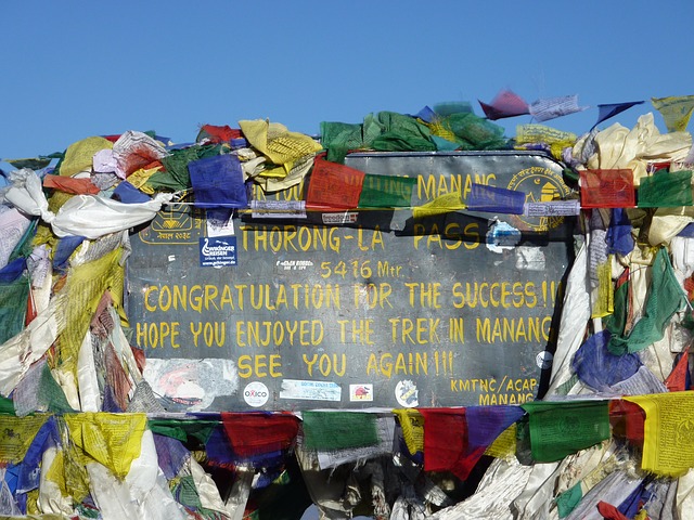
The Annapurna circuit travels up and around the world’s deadliest peak and climbs over one of the highest pass in the world: Thorong La Pass (5,416 m/ 17,769 ft). And, although this may be an overused phrase in the Himalayas, it is also one of the world’s most beautiful hikes.
This long circuit passes iconic peaks such as Machapuchare or ‘Fish Tail’ (6,993 m/ 22,943 ft), Annapurna I (8,091m/ 26,545 ft), II (7,937m/ 26,040 ft) and III (7,555 m/ 24,786 ft) and, on the opposite side of the deepest of gorges, the towering Dhaulagiri (8,167m/ 26,795 ft).
Holders of some of the highest death rates of any mountains in the world, you may feel glad to only be walking near, rather than up, these dominating peaks.
Almost all hikers head anti-clockwise, to take advantage of the more gradual elevation gain. Most tour companies also take this direction, staying at tea houses en route. Unlike the two base camp walks above, the Annapurna Circuit can be walked independently, though booking accommodation and thorough preparation are essential for a trip’s success.
From Kathmandu, you travel either directly to the start of the trek in Besi Sahar (830 m/ 2,723 ft) to the south-east of the massif, or to Pokhara (900 m/ 2,953 ft), Annapurna’s tourist hub. The end of the trek can be taken at numerous points, including Jomsom airport in the west, a choice which cuts around six days off the walking time. The full circuit ends in Pokhara, Annapurna’s tourist hub to the massif’s south.
The initial walking is over a roughly cut road, work on which first began in the 1980s and continues to require maintenance today. It is damaged and sometimes even destroyed by the huge boulders that slide down from the mountain tops during regular rainstorms.
Beyond this, the rougher hiking trail undulates up along the northern side of the Annapurna massif, through the Marshyangdi River valley. This leads to the Thorung La Pass, a notorious section of the walk that features prominently on almost every hiker’s account.
The route then turns around the north-west of the massif to head back south via the Gandaki River valley. The main challenge faced in this last section is the fierce wind, pummelling hikers as they head through one of nature’s greatest wind tunnels.
A popular route, and growing ever more so, the Annapurna circuit offers some of the most diverse landscapes, largest elevation changes and different cultures of any Himalayan trek.
Gangtori Glacier Trek (India)
From/to: Gangotri to Gomukh (and return)
Distance: 36 km (22.5 miles)
Walk time: 6 to 9 days
When to walk: May to June and August to October
Short description: Hike to the source of the Ganges, India’s greatest river, on a pilgrimage route that, while short, offers more than its fair share of challenge and wonder.
Gomukh is the place where India’s greatest river begins, and is the destination for this comparatively shorter Himalayan hike. Passing among the Bhagirathi mountains in the state of Uttarakhand in northern India, this is a trek into ‘the Land of the Gods’.
The Ganges, or Ma Ganga, holds significant cultural, social and spiritual significance among the Indian population. In the Hindu culture, the river is considered a god, brought to Earth in order to cleanse it and its inhabitants.
Flowing through the north of the country, it has been a source of water for drinking, washing and worshipping, today providing for some 450 million people. Unfortunately renowned more for its pollution these days, significant funds are being directed at cleaning efforts to retain its usefulness for a dependent population.
Most visits will begin from the holy city of Rishikesh or the city of Delhi, followed by a train and drive over a day or two into the Garwhal Himalayas proper. Trekking officially begins from Gangotri (3,048 m/ 10,000 ft), home to the nearby Gangotri shrine (3,200 m/ 10,499 ft), which attracts pilgrims from across the world. It was here that Lord Shiva is said to have sat and received the Goddess Ganga into the river.
The trek itself lasts only three or four days—as long as the journey to the starting point. The first day follows the roaring Bhagirathi river to Bhojwassa (3,792 m/ 12,441 ft), in the shadow of the mountains. The next day treks up to Gomukh (3,890 m/ 12,762 ft), with an option to continue higher with a traverse of the glacier to Tapovan (4,463 m/ 14,642 ft) or a return to Bhojwassa. The first variation adds about a day to the trek.
The return follows the same route back.
Gomukh/Gaunukh means ‘cows snout/mouth’ and refers to the cave that is thought to have formed at the foot of the glacier from where the Ganges begins its long journey south and east. Today, it looks more like the end of a glacier and abrupt start of a river, but the name allows some imagining of how it once looked, before the glacier retreated to its current position.
Many trekkers will take a holy dip in the river; probably one of the few places along Ma Ganges that it would be safe to do so (if pretty damn cold!). After the strenuous inclines of the hike, your body may thank you if you choose to join them.
Snowman Trek (Bhutan)
From/to: Drukgyel Dzong to Daralo
Distance: 348 km (216 miles)
Walk time: 17 to 26 days
When to walk: May to November (later season is best)
Short description: Winding through the high mountain passes across the top of Bhutan, this walk of record-breaking superlatives should be a bucket list entry for hikers looking for a high-altitude challenge and unique cultural experience.
In a country little known to most people in the west, the Snowman Trek offers the opportunity to learn about Bhutan and its people, all the while taking on “the toughest trek in the world”. It’s named after the six mountains along the way that reach skyward at over 7,000 m (23,100 ft).
Climbing over nine mountain passes in excess of 4,500 m (14,764 ft) over the course of the walk, this is the highest and longest trek in the Himalayas. An added motivation for hikers is the opportunity to see the elusive and increasingly rare snow leopard, along with other mountain wildlife.
Hikes in the Himalayas of Bhutan are accessed through the airport in Paro (2,300 m/ 7,546 ft). Most hikers typically begin their trip with a couple of days acclimatising to this starting elevation. A two-day minibus journey follows, heading through the capital, Thimphu, and on to the trailhead at the Drugyel Dzong in the Bumthang valley.
The route then heads on a wide semi-circle north, east and eventually south. There are a number of possible route variations, given that the Snowman Trek uses and extends existing hiking routes, as well as a network of centuries-old pilgrimage and village trails.
Beginning from Drugyel Dzong in the west, you follow the route of the Jomolhari Trek north passed the mountain, Jomolhari (7,314 m/ 23,996 ft) and on to Laya in the shadow of Masagang (7,194 m/ 23,602 ft).
The path then cuts east while the other trek heads south to Gasa, and you begin walking on the path marked as the Snowman Trek route. This cuts between the mountain ranges of northern Bhutan to the village of Thangza. Here, it splits into two variations for the final section.
The shorter option heads south from Thangza, eventually arriving in Chuserbu. This route cuts the total walking time down to between 17-20 days.
The longer route (sometimes called Snowman Trek II) heads south-west, gently curving down to Kurjey near the city of Jakar. It uses every bit of the 24-26 days. Staying higher for longer, you pass through the base camp of what is argued to be the world’s highest unclimbed mountain: Gangkar Puensum (7,564 m/ 24,816 ft).
Regardless of the route you choose, this long distance walk offers dense forest, high lakes, glaciers, waterfalls and a diverse range of the Himalayas most treasured fauna (bears, tigers and leopards tracks are all cited in this account).
So for an adventure into the as yet unknown, Bhutan may be your next Himalayan destination.

LATEST BLOG POSTS
I quit the rat-race to live a more adventurous life. This is my journey.