
0
items
$0
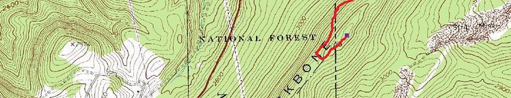
BACKBONE MOUNTAIN IS SITUATED AT THE BORDER BETWEEN THE U.S. STATES OF WEST VIRGINIA AND MARYLAND, THUS FORMING A SECTION OF THE EASTERN CONTINENTAL DIVIDE. IN MARYLAND, BACKBONE MOUNTAIN STANDS AT AN ELEVATION OF 1,116 M (3,360 FT), MAKING IT STATE’S HIGHEST POINT.
Backbone Mountain Ridge extends for approximately 63 km (39 miles) southwest to northeast, from Tucker County, West Virginia to Garrett County, Maryland. Climbing the mountain is relatively easy with a splendid panorama awaiting at the highest point. On the top of the summit there is a sign commemorating the peak’s elevation – Hoye-Crest, as well as a picnic table where visitors can rest after their climb. Hoye-Crest was named after Captain Charles Hoye, founder of the Garrett County Historical Society.
The location is accessible all year round being a popular hiking destination among both locals and tourists. The easiest route by foot runs along the Maryland High Point Trail, ascending Backbone Mountain along Monongahela National Forest to the West Virginia-Maryland state line. The trail then leads north along the state line to the Hoye-Crest.
THE FIVE HIGHEST PEAKS IN MARYLAND:
- Backbone Mountain - 1,116 m (3,360 ft), in the Allegheny Mountains, Maryland, United States.
- Negro Mountain - 937 m (3,075 ft), in Garrett County, Maryland, United States.
- Meadow Mountain - 921 m (3,022 ft), in Garrett County, Maryland, United States.
- Big Savage Mountain - 912 m (2,991 ft), in Garrett County, Maryland, United States.
- Dans Mountain - 883 m (2,898 ft), in Allegany County, Maryland, United States.

LATEST BLOG POSTS
I quit the rat-race to live a more adventurous life. This is my journey.