
DENALI (ALSO KNOWN AS MOUNT MCKINLEY) IS THE HIGHEST MOUNTAIN IN THE US STATE OF ALASKA , AS WELL AS IN NORTH AMERICA (6,190 M (20,310 FT)) AND THE THRID HIGHEST PEAK ON THE PLANET AFTER MOUNT EVERESTIN CHINA-NEPAL AND ACONCAGUA IN ARGENTINA.
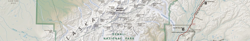
Mount Denali is located in Denali National Park some 210 km (130 miles) north-northwest of Anchorage. The mountain is part of the Alaska Range, thus, the area is rather seismically active, causing significant earthquakes throughout the state. The top of the summit is permanently covered with snow and glaciers of up to 48 km (30 miles) long. The climate on top of the mountain is extreme with temperatures dropping to minus 60 degrees Celsius (minus 75 degrees Fahrenheit).
Mount Denali is one of the most popular climbing destinations in North America with only 50% of all ascents being successful. Due to its far northern location, the mountain is often climbed between May and September. The first successful documented ascent of the mountain took place in 1913 when Hudson Stuck, Harry Karstens, Walter Harper, and Robert Tatum attempted to reach the peak via the south ridge.
THE FIVE HIGHEST PEAKS IN ALASKA:
- Denali - 6,190 m (20,310 ft), in Alaska, the USA.
- Saint Elias - 5489 m (18,009 ft), in the Saint Elias Mountain Range, Alaska, United States.
- Mount Foraker - 5304 m (17,400 ft), in the Alaska Mountain Range, Alaska, United States.
- Mount Bona - 5044 m (16,550 ft), in the Saint Elias Mountain Range, Alaska, United States.
- Mount Blackburn - 4996 m (16,390 ft) Wrangell Mountain Range, Alaska, United States.

LATEST BLOG POSTS
I quit the rat-race to live a more adventurous life. This is my journey.