
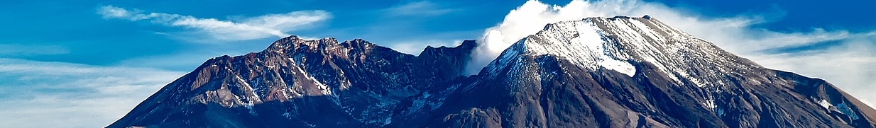
One third of a famous Native American myth, the ‘smoking mountain’ of Mount St Helens (2,549 m/ 8,365ft) became infamous when it spectacularly erupted in 1980, sending sections of its summit cone flying far off into the wilderness.
Name: Mount St Helens
Height: 2,549m (8,365 ft)
Location: The Cascade Range in Washington State, USA.
First Climbed: 26 August 1853 by Thomas J Dryer and three others.
Climb Time: 6-8 hours
Best Time to Climb: May to September
INTRODUCTION TO MOUNT ST HELENS.
On 18th May, Mount St Helens literally blew its top, tragically claiming 57 lives. Some 396 m (1,300 ft) of its elevation was also lost that day, leaving “a mere shell of what had been a beautifully symmetrical cone”.
But this does not detract from climbing the mountain today. After all, how many active volcanoes can you ascend within a day, with views of the spectacular nearby mountains such as Mount Rainier (4,392 m/14,411 ft) and Moot Hood (3,429 m/ 11,249 ft)?
Jump to Hiking and Climbing Guide.
This mountain is an invitation to gaze upon the raw power of our Earth and to stand on top of a mountain that has been both formed and broken with the Dionysian power of volcanic eruptions.
Put Mount St Helens on your bucket list. Whether you’re a mountain climber, geologist or just fascinated to see the power of nature up close, this mountain has plenty to offer you.
HISTORY OF MOUNT ST HELENS.
The history of eruption is carved into this mountain’s appearance and history.
The Native American name for the mountain is Louwala-Clough, meaning ‘the smoking mountain’. It gained its modern name in 1792, when British naval captain, George Vancouver, named the peak after the Baron of St Helens, Allene Fitzherbert (perhaps he thought Mount Fitzherbert didn’t have the same ring to it!)
Vancouver also named several other Cascade peaks after British naval officers: Mount Baker (3,286 m/ 10,781 ft), Mount Hood, and Mount Rainier.
Before the 1980 eruption, Mount St Helens was nicknamed the ‘Fujiyama of America’. This was a reference to the symmetry of the mountain, similar to that most famous Japanese mountain, Mount Fuji (3,776 m/ 12,338 ft).
- Read about other important US & North American mountains in our Mountain Info Page
- Read our Introduction to the Colorado 14ers
- Check out this article on my visit to another volcano; Cotopaxi, in Ecuador
This historic symmetry plays into the main Native American myth that ties Mount St Helens to nearby Mount Hood and Mount Adams (3,743 m/ 12,280 ft). You can read a full description of this myth in our Mount Hood article.
In short, Mount St Helens was a beautiful woman who guarded an eternal fire on a bridge that spanned the Columbia river. Two warriors fought over her, causing masses of destruction. This led to all three being cursed and turned into mountains.

But it is the history of eruptions that have brought Mount St Helens the most modern renown. You can read more about the 1980 eruption below.
But the mountain was active long before this, with modern accounts including a 26-year eruptive phase from 1831 to 1857. It then lay dormant, gaining the trust of visitors for over a century until this was violently shattered in spring 1980.
On 27 March 1980, Mount St Helens erupted suddenly after two weeks of localised earthquakes, heralding the first major eruption in contiguous United States since Lassen Peak (3,189 m/ 10,463 ft), California, which erupted from 1914 to 1917. This was the beginning of months of violent activity on the peak.
GEOGRAPHY OF MOUNT ST HELENS.
Mount St Helens is an active stratovolcano in the south-west of Washington State, north-western USA. It is part of the Cascade Range, the long sweep of volcanoes that lines North America’s west coast and is the smallest of Washington’s five volcanoes.
It is also part of the ‘Ring of Fire’, a collection of volcanoes that stretches far out into the Pacific. These volcanoes are responsible for the most frequent and violent eruptions today.
Formation of the mountain.
Composite volcanoes such as Mount St Helens are formed through the action of repeated eruptions. The symmetrical appearance that is common for such mountains is created by the equal layers of lava, ash and debris that settle after each eruption.
The steep sides of this mountain suggest that these eruptions have tended to be violent and powerful throwing debris far and wide. In contrast, less violent eruption create the shallow-sloped, gently erupting Hawaiian volcanoes, as the lava trundles down the mountain side.
Mount St Helens’ classical symmetry is no longer evident however. The 1980 eruption removed vast sections of its north side, leaving it very lopsided.
Eruptions.
This mountain was made by eruptions but in 1980 it was also largely destroyed by one.
After the initial activity in March 1980, hundreds of earthquakes and ejections of ash and steam continued for the next two months. These released debris from the summit dome only, initially from a crater on the eastern side, then one in the west, before they both enlarged enough to create a single crater.
It was during this period that magma was forced into the mountain’s summit dome, building up intense pressure in the summit. This was released tragically on 18th May through the unstable north flank.
Huge quantities of debris (including the largest landslide-debris avalanche ever recorded) flowed or were blown far away from the mountain, claiming 57 lives, including volcanologist David Johnston.
From the start of the earthquake that triggered the eruption to the collapse of the flank took little more than 20 seconds.
Minutes later, sections of Mount St Helens were far from where they had been when the sun had risen only a couple of hours earlier. As the mountain blew its top (or its side more precisely) it discarded 396 m (1,300 ft) in elevation (it was 2,950 m/ 9,677 ft previously) and 3.4 billion cubic yards of debris.
Images of the enormous eruption give a sense of the scale and drama of this event. Eruptions continued throughout the year, including another spectacular event on 22 July.
Following the eruption, today’s Mount St Helens has a huge titled crater that reveals the mountain’s insides to anyone stood to the north. It is a far cry from the symmetrical elegance of pre-1980 Mount St Helens, but no less fascinating to gaze upon.
WILDLIFE OF MOUNT ST HELENS.
Flora.
In 1980, some 518 sq km (200 sq miles) of forest were destroyed, much of it buried under 10-195 m (33-640 ft) of sand and rock.
Today, much of the old growth forest destroyed on the mountain’s slopes remains relatively barren. Considering the amount of mud and debris that fell on this landscape (even choking the Toutle River) that any flora would return in such a short space of time is remarkable.
But, in places, the recovery of flora was fast, dramatic and abundant. Some plants were saved as they were buried beneath snow at the time of the eruption, revealed as the returning elk and deer broke up the ash surface.
On the mountain itself, the volcanic rock and snowpack have always prevented vegetation from growing effectively (as noted in the account of the first ascent, below).
By the lower elevation streams, willow, alder shrubs create woody thickets, while cottonwood trees populated the plains. Further up, dense growths of conifers are most common.
Plant life is more limited, with 20 of the 95 vascular species wiped out by the 1980 eruption. Mount St Helens has about a third to a half of the species variation compared to surrounding peaks, but small meadows do dot the landscape between trees and barren volcanic rick.
Fauna.
Many animals were displaced by the eruption, and some took many years to return to the slopes. Mountain goats, for example, had an estimated hiatus of seven years from the mountain, though they are now a regular fixture.
It was the elk and deer who returned fastest. With decent fat and water reserves, they were able to roam a large area in search of the highly nutritious sprouting vegetation. Their population boomed as hunting was also banned and the following winters were warmer than usual.
Black bears and cougars also returned in time. The black bears return coincided with the regrowth of conifer forests, while evidence of cougars have been found in recent years (they are highly elusive at the best of times!)
Smaller animals are also now thriving. Many deer mice, yellow-pine chipmunk and Trowbridge’s shrew are thought to have survived the eruption by living in protected areas and are certainly populous on the mountain today. In total, 35 small mammal species live on and around the peak, also including beavers, as well as around 15 species of amphibian.
Bird life returned quickly, though the most dramatic population boom occurred around ten years after the eruption as their typical habitats ad recovered sufficiently.
Birds found on the peak include some with fantastical names, including: the warbling vireo, the black-headed grosbeak, and the ring-necked diving duck.
Osprey, bald eagles and red-tailed hawks are some of the more impressive flighted creatures, and are best spotted close to the ponds, streams or wetlands.
FIRST ASCENT OF MOUNT ST HELENS.
Mount St Helens was the first major peak to be climbed along the Pacific Coast, a feat achieved on 29 August 1853.
Thomas Jefferson Dryer, a newspaper editor from Portland and three other men ascended the peak via Swift Creek and claimed to leave a “pyramid of loose stones” on the peak, though no subsequent ascent party ever located these.
Their ascent shows something of the rapidly changing nature of this peak. On reaching the summit, Jefferson took a bearing for a steaming vent within the summit crater. Located on the north-east side of the crater, this vent had been part of the 1842-1844 eruption but had cooled enough by 1875 to be covered with a blanket of snow.
Their account reflects a “continual uphill ascent” passing “blackened piles of lava which were thrown into ridges hundreds of feet high in every imaginary shape”. From the top, they identified (wrongly) and marvelled at the surrounding peaks, the first men to stand and gaze out upon them.
HIKING AND CLIMBING GUIDE FOR MOUNT ST HELENS.
While the optimal time to climb Mount St Helens is during the main permit season of May to September, it is also popular for ski and snowshoe ascents from early February onwards.
Winter climbing avoids the permit quota system, which limits the number of climbers on the mountain during a season, (you will still need a permit to go over 1,460 m (4,800 ft)). Moreso, it avoids the scree and ash which, as we’ll see, makes climbing Mount St Helens’ modest height an ample challenge!
There are three main routes: Monitor Ridge, Worm Flows/Swift Glacier and Butte Camp.
Monitor Ridge Route.
The most popular is this day-hike through woodland and ridgelines that approaches the summit from the south.
One advantage of the Monitor Ridge Route is the view that is revealed at the summit. Climbing from the south leaves the spectacular destruction of the north face to be seen only once you reach the summit crest. And what a sight it is.
The route begins at the Climbers’ Bivouac, a popular overnight spot before a summit attempt, (it’s also known for big summer parties, but you can camp a little distance away if you value sleep more!) The first 3.5 km (2.1 miles) is through forest and open meadows and climbs 305 m (1,000 ft) via the Ptargmigan Trail.
Passing the Loowit Trail, which circuits the peak (see below), you ascend to Monitor Ridge. More difficult terrain follows, with 762 m (2,500 ft) gained via boulder fields coated with ash pumice—sharp rocks that’ll make you glad you brought gloves and long trousers.
Beyond this is the final summit climb of 305 m (1,000 ft) over more scree-like terrain (still covered in ash). This is an exhausting section as you slip and slide to the summit (though not in winter).
Descent is by the same route, and in winter can include some careful glissading. In total, this is a 14.5 km (9-mile) roundtrip with 1,402 m (4,600 ft) of elevation gained. Given the terrain it may well feel like you walked a lot further!
Worm Flows/Swift Glacier Route.
The Worm Flows Route is a 17.4 km (10.8-mile) return and gains 1,737 m (5,699 ft). It is popular in the winter, being the most direct summit route during this season.
It is named after the rocky lava flows that surround the trail. It is more technically demanding than the Monitor Ridge Route, but only requires basic mountaineering skills.
The trailhead is the Marble Mountains ‘Sno Park’ to the south-east of the Climber’s Bivouac site. The route climbs to the east of the Monitor Ridge Route. It follows the site of a former glacier (Swift Glacier) up the western side of Swift Creek, passing Chocolate Falls (1,128 m/ 3,700 ft) to eventually gain the crater rim.
From this is false summit, worth a pause to take in the views, head west along the rim to reach the true summit. Descent is via the same route. This route tends to be less well-marked than the more popular Monitor Ridge Route, and may require a little more scrambling.
Butte Camp Route.
The final trail is the Butte Camp Route, a mish mash of several trails. From the south-west of the mountain, use the trailhead for the Toutle Trail, which almost immediately requires you to a lava flow, before gaining the Kalama Ski Trail after 1 km (0.6 miles).
Just under 1 km (0.6 miles) further on you’ll reach the Butte Camp Trail, which leads you up to Butte Camp (1,219 m/ 4,000 ft). This heralds the start of some steep switchbacks through old-growth fir forests and wildflower meadows, leading to the circular Loowit Trail.
At the camp, the official trail runs out. It is up to you whether you feel confident enough to continue traversing the terrain to gain the summit. This requires improvisation to cut a route through the rocky terrain that lies ahead.
INFORMATION ON TREKKING AROUND MOUNT ST HELENS.
One option for those not keen on a summit ascent is the Loowit Trail. This circuits the mountain around 1,433 m (4,700 ft) and can be gained by the Butte Camp Trail or from the Climbers’ Bivouac (both above) among others.
It is no easy hike though, and at 45 km (28 miles) is by far the longest option not eh mountain.
Dropping in and out of gullies left by the lava and walking by the majestic Spirit Lake, the Loowit Trail reveals the vastly changed landscape created by the 1980 eruption. Plan any overnights carefully, as campsites on the route are sparse.
For some shorter hikes dotted around the mountain, have a read of these local recommendations for exploring Mount St Helens.
A great place to see the local wildlife is with the 3,940-acre Mount St Helens Wildlife Area. It is criss-crossed with creeks and rivers, around which much of the area’s wildlife can be easily spotted.
With Mount Hood, Mount Adams and Mount Rainier (most challenging) in close proximity to Mount St Helens, the summit ascents of all of these spectacular peaks are also easily accessible and variously challenging.