
Photo by Darkest tree
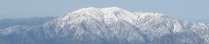
This mountain, towering over one of the world’s great cities, has a split personality. Whether you’ll come to know it as Mount San Antonio or Mount Baldy, the peak is a centre of skiing and summer hiking in southern California.
Name: Mount San Antonio
Other names: Mount Baldy / Old Baldy (colloquial); Yoát / Joat (Tongva)
Height: 3,068 m (6,224 ft).
Location: In the San Gabriel Mountains, near LA, California, USA.
First Climbed: unknown.
Climb Time: Half a day.
Best Time to Climb: June-October, but possible year-round.
Introduction to Mount San Antonio
Previously home to one of the most numerous Native American populations in California, this mountain is far less scarred by the 19th Century gold rush than others nearby. Its history is one primarily of recreation, with some nearby star-gazing too.
A rewarding climb from any direction, with adventure routes to suit any fitness level (including the ski lifts which knock off a fair amount of one route), Mount San Antonio is a trademark of what American’s might call ‘the great outdoors’.
Although its official name is Mount San Antonio, so many of the locals and mountaineering community call it Mount Baldy that we’ve decided to as well. So our titles will keep the official name, while the text will use local vernacular.
So you choose: Mount San Antonio or Mount Baldy? We’ve heard it’ll respond to either.
Jump to Hiking & Climbing Guide
History of Mount San Antonio
The official name, Mount San Antonio, is said to come from the 1790s. Padres of the San Gabriel mission named the peak after St. Anthony of Padua, a Franciscan priest from the 13th Century, said to work miracles.
Another account places the naming as having occurred around 1840 by ranch owner Antonio Maria Lugo. The reasoning for the name, however, is the same.
Many surrounding natural and manmade landmarks share the mountain’s official name. These include the adjacent canyon and the creek that flows from the mountain’s challenging southern slopes.
The common name, Mount Baldy, comes from the early American settlers, who were mainly miners. On surveying the land, they named the bare fell-field on the south face, Baldy Bowl. As this is the prominent feature seen from LA, the name stuck to the mountain as a whole.
The indigenous people were the Tongva, present in the Los Angeles basin and surrounding ranges for several thousand years. Their name is an endonym, meaning it is not the name used by the people themselves but rather was given to them. In this case, ethnographer C Hart Merriam gave it to them in 1903.
At the time of the settlers’ arrival, there are thought to have been up to 10,000 Tongva people in the region. Unfortunately, by the early 20th Century, no fluent speakers of the Tongva language remained.
The San Gabriel Mountains were declared a national monument in 2014, adding to its status as part of the Angeles National Forest. These statuses aid the preservation of the environment; helping the 15 million people who live within 90 minutes drive of the peaks to fulfil their ‘responsibility to be good stewards of these landscapes for future generations.’
Mount Baldy is also one of the most photographed natural features in southern California, gracing numerous postcards and brochures.
But it is not just looking in to these mountains that make them well known. There is a great history of looking out from them.
From nearby Mount Wilson (1,740 m/ 5,710 ft), two particular scientists began to change the way we look beyond our world. Edwin Hubble and Harlow Shapley used the modern facilities, built on the summit at the dawn of the 19th Century, to gaze towards the stars.
The weather patterns are such that this area offers some of the clearest skies from which to view the cosmos. Hubble’s work led to the most famous telescope sent out into space to be named after him. Today, the observatory boasts some of the best technology to continue the observation of worlds beyond our own.
Geography of Mount San Antonio
The highest peak in the San Gabriel Mountains, and third highest in southern California, Mount Baldy is part of a range that separates the arid Mojave Desert from the metropolis of Los Angeles.
On one side lies a world-famous, sprawling city of nearly 4 million people, on the other North America’s driest desert, with its sparse (though growing) population.
Mount San Antonio is part of a 48 km (30-mile) long crescent-shaped massif, which contains some of the range’s highest peaks. To the south of the mountain is the deep San Antonio canyon, into which the San Antonio creek drains.
The San Gabriel Mountains are 110 km (68.5 miles) long and are part of a group called the Transverse Ranges. These are named as such because they lie east-west in contrast with most ranges in the area, which run north-south along the San Andreas Fault.
The Transverse Ranges are situated in the south of California between the Coast Ranges in the north and the Peninsular Ranges in the south.
The San Andreas Fault, whose tectonic action over millions of years has grown the impressive west coast mountain ranges, lies on the north of San Gabriel Mountains. These mountains are normal fault-block mountains. This formation history is reflected in their rolling peaks with a steep relief on one side only (south face).
Numerous canyons and river valleys dissect the range, including the Cajon Pass, which marks the eastern side of Mount San Antonio. Down the slopes of the mountain and across the range, gushing waterfalls and creeks mark the landscape and give hikers a moment to pause and refresh in the summer heat.
Only three peaks separate Mount Baldy from this eastern point, with Cucamonga Peak (2,700m/ 8,858 ft) the last high-point before the steady descent into the valley. Across the valley to the east lie the San Bernadino Mountains.
Other significant peaks in the San Gabriel Mountains:
• Pine Mountain – 2,941 m (9,648 ft), the second highest peak in the range.
• Mount Harwood – 2,913 m (9,556 ft), named after the first female president of the Sierra Club, Aurelia Harwood; a subsidiary peak of Mount San Antonio.
• Mount Baden-Powell – 2,865 m (9,399 ft), named after the founder of the Scout movement.
• Mount Islip – 2,510 m (8,250 ft), site of the historical monument, the Mount Islip fire lookout tower.
• Mount Wilson – 1,740 m (5,710 ft), home to the Mount Wilson Observatory (see above).
Each year, between December and March, snow lies on the ground above 1,220 m (4,000 ft), though the Mediterranean climate melts this is in the spring. The most snow and rain falls on the area of the range around Mount San Antonio.
Come summer, the higher reaches of the mountain then come to reflect the light grey/brown appearance of the Mojave Desert to the north.
Wildlife of Mount San Antonio
Flora.
The surrounding areas, once free of the urban smog, are sparsely covered in a yellow pine forest. Filled with species common to the area such as lodgepole pine, white fir and Jeffrey pine, this evergreen forest will be familiar to American mountain enthusiasts.
The trees above 2,750 m (9,000 ft) become even more sparsely scattered, as the howling winds and yearly snowfall mean only the toughest of specimens survive long enough to grow to a decent height.
The trees here become krummholzed – a German term meaning ‘crooked, twisted wood’.
High on the slopes the plant life disappears, though the tree line is far from defined. Around 2,900 m (9,500 ft) is considered the beginning of the unforested subalpine zone. This scattering of trees across the slopes leads Mount Baldy to earn its name.
There are significant wildflower populations on the mountain’s slopes. These include a number endemic species, which flourish in the variable climate.
The San Gabriel alumroot is saxifrage, which blossoms with pink, bell-shaped flowers. It grows in the rocky areas, blossoming in July and August. But don’t pick it; this wildflower is listed as endangered.
Other native species includes the gray monardella, pumice alpine gold and Parry’s pussypaws.
Fauna.
High on the slopes, the desert bighorn sheep are a subspecies of a common California mountain resident. As they face no great threats from predation or territory competition, they are relatively numerous. Their great curving horns should help you spot them easily enough.
Until the late 19th Century, grizzly bears roamed the area. Hunted to extinction, the last of them was killed in 1894 by Walter L Richardson. The black bears, now found in the area, are descendants of a troublesome bunch who were introduced from Yosemite in 1933. However, they are typically shy, so there’s little to fear as you probably won’t catch sight of or run into one.
Many small mammals scamper these slopes, including the desert cottontail, black-tailed jackrabbit and the fiendishly cute Merriam’s chipmunk.
First Ascent of Mount San Antonio
Little information is available about the first ascent of Mount Baldy.
As no routes are particularly technically difficult, it is unlikely that the first ascent was a particularly notable occasion. Chances are very high that the indigenous population had been traversing and ascending the mountain for many years previously.
Climbing Guide for Mount San Antonio
There are four main routes up Mount Baldy, one from each primary direction.
• East route or Baldy Notch/Devil’s Backbone.
This route follows the route of ski lift, so there is always the opportunity to take an easier option up and/or down. If so, this knocks around 6.5 km (4 miles) and 457 m (1,500 ft) of elevation.
From the Manker Flat car park, follow the dirt track known as Falls road to the Baldy Notch ski lodge. This is an easy walk of about 3 km (2 miles). The ski lift routes are then followed with no exact route defined such is the openness of the route.
Taking the Fire road to the ridge from the end of the ski lift, you arrive at the Devil’s Backbone, a long sloping ridge-line of scree that leads to the summit. In total, the return trip is 21 km (13 miles) but poses no great elevation gains or technical challenges.
This is a summer scree walk to the summit, taking from half to a whole day.
• South route or Baldy Bowl route.
A more difficult prospect than the above route with much steeper climbing. It is only 13.5 km (8.4 miles) long, but what it lacks in distance it makes for in steepness. Nonetheless, it poses no technical difficulties, except finding the trailhead at the start perhaps!
From Manker Flats (to the south-east) walk in on the San Antonio Falls road to the Ski Hut trail (approx. 1 km (0.5 mile)). The trail can have icy sections, especially early and late in the season, so be careful.
From the Ski Hut (passed San Antonio Falls), head directly up Baldy Bowl to follow the trail. This will be an hour’s strenuous walking, in which you gain 488 m (1,600 ft). The simplest chutes to follow for exit lie towards the centre of the bowl.
The summit plateau is a further 10 minutes of walking more gradually uphill. In winter, under the right snow conditions, the descent can be much faster as you can glissade down the steep bowl.
While winter hiking is possible, precautions do need to be taken. With a steep relief on the south side, and deep snow blanketing the upper slopes, there have been a number of deaths on this mountain. In the winter season of 2015/2016, four hikers fell to their deaths, reminding us that no mountain is climbed without risk.
• West route or Old Mt Baldy trail.
Less commonly used than the East route, this trail is arguably the oldest (built in 1889) and reputably the most rewarding hike. Following the long south ridge, it climbs from Mount Baldy village in the west.
A return trip of 20.5 km (12.8 miles), this route gains 1,751 m (5,744 ft), and some sections lead you to feel every part of it!
It begins from the village before taking you through Bear Canyon. Switchbacks through open conifer forest begin the real ascending, before gaining the ridge and continuing to head up. The sparse trees and quick elevation gain offer fantastic, changing views all the way up, which is certainly part of the route’s attraction.
• North route or North Backbone trail.
This is a rewarding, challenging hike for more experienced hikers. Rated up to class II, this route bags three peaks in one walk and includes some punishingly steep sections of unstable scree. With ridge-line walking for much of the route, this is not a route suitable for everyone, but those who can do it, should.
You summit Pine Mountain (2nd highest peak in the range) and Dawson Peak (3rd) before climbing Mount Baldy. Between each one, the drops down to the connecting saddles can feel demotivating, undoing much of your good work. But the reward of submitting all three peaks (two of them twice as you go back the same way) is massively rewarding.
Information Trekking around San Antonio
For climbers, the best spot to head to is the slot canyon, found in the canyon of the San Antonio Creek at around 1,220 m (4,000 ft). This canyon was formed by sudden release of immense water pressure, caused by a dam that was formed by an enormous prehistoric landslide blocking the river.
The narrow slot canyon now contains routes up to US Grade 5.11, equivalent E4 or E5 in British levels. This equates to high-level sport climbing.
Given the inherent dangers of sudden flash floods in slot canyons (there are frequent deaths from this around the world), these climbs are recommended for experienced climbers only, or those going with experienced, local adventure guides.
In the wider Angeles National Forest, there are over 1,130 km (700 miles) of trails, including five designated wilderness areas to explore. Those nearby to Mount Baldy are considered some of the most strenuous on offer, so for an easier trek, head west.
Mount Baldy is also a great ski area, with a season that runs from late December-March. The main resort caters to hundreds of skiers and snowboarders each season enjoying the mountain’s challenging slopes.
First opened in 1952, it offers 26 different runs up to 4 km (2.5 miles) long. With over 4.5 m (15 ft) of average annual snowfall, skiing has become a predictably popular fixture with local LA residents looking to escape their urban hum.
The area’s history of recreational usage dates back to the late 19th Century, when lodges, lifts and inns were built on the slopes. So, if there’s anywhere in the US where they’ll no how to look after you after a long day on the mountain, it’s Mount Baldy!