

Wih the highest concentration of 4000m peaks anywhere in the Alps Monte Rosa offers perhaps the greatest possibility to the budding or experience climber.
Name: Monte Rosa
Height: 4634m (15,203ft).
Location: Swiss / Italian border. Between Zermatt, Switzerland and Macugnaga, Italy.
First Climbed: 1st August 1855 by Charles Hudson and a team of English alpinists and Swiss guides.
Climb Time: 2-3 days from Zermatt, Switzerland (Swiss Normal Route).
Best Time to Climb: June - September
Introduction to Monte Rosa.
A domed massif of numerous jagged peaks, the Monte Rosa massif is a landscape of angular granite and destructive glaciers. The second highest peak in the Alps with the second longest glacier, this mountain is far less high profile than Mont Blanc, but those who do venture here are rewarded with stunning views and innumerable challenges.
Monte Rosa offers the chance to take in the true scale of this enormous European mountain range. Situated in the Central Alps, panoramic views from the summit to the South and West offer up The Alps' most famous peaks; Mont Blanc, Matterhorn and the Weisshorn are all visible from the top on a clear day.
Jump to Climbing & Walking Guide
Lying along the Italian-Swiss border, the Monte Rosa massif has been an object of fascination and adventure for locals and visitors all the way back to Leonardo da Vinci. Da Vinci mentioned the mountain by its older name, Monboso, in his writings from the early 1500s although his passing interest did certainly not reflect an enthusiasm for mountains or wilderness.
A challenge for hikers, mountaineers, alpinists and climbers alike, Monte Rosa offers up a vast range of adventures for all its visitors. For those reaching for some introductory 4000m summits or even some challenging alpine faces Monte Rosa holds a challenge for anyone taking it on.
A note about language.
Where different names are listed in this article, the Swiss name will be first, followed by the Italian and any local dialects.
Where necessary we have also included English translations. As many peaks are named after the individuals who first ascended them, this has not always been necessary, (such as Zumsteinspitze which was named after Joseph Zumstein).
History of Monte Rosa.
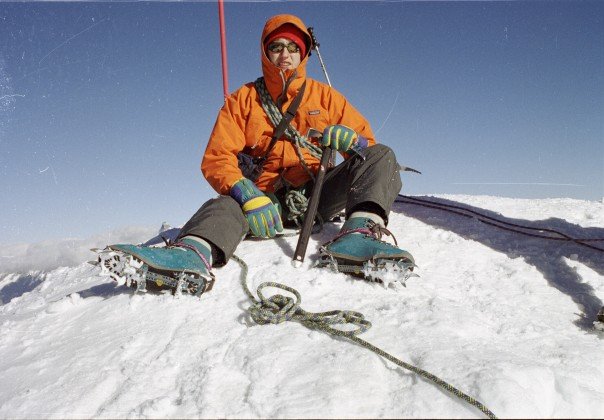
The Armchair Mountaineer on the Summit of Castore (4228m).
Monte Rosa translates directly as ‘the pink mountain’. But its genuine root is the French rouése, (also the local Valle d'Aostan dialect, roëse), simply meaning ‘glacier’. This name aptly describes the significant ice flows that cover the sides of this mighty mountain and have informed its dramatic appearance.
This mountain or rather this 'massif' has been previously known by various other names. These include: Mon Boso/ Monte Biosa (Italy), and its highest peak; Dufourspitze has also gone by the name of Gornerhorn and Höchste Spitze (Switzerland).
Dufourspitze (4634m/ 15,203ft), was named after General Guillaume-Henri Dufour. He created the Dufour map, the topographical map of Switzerland, between 1845 and 1865, and was also a co-founder of the Red Cross.
Europe’s highest hut is located on the slopes the Monte Rosa peak Signalkuppe (4554m/ 14,941ft). The Margherita Hut (4554m/ 14,931ft), is named after Italy’s late 19th Century Queen consort Margherita of Savoy. It was built between 1890 and 1893 and has been a refuge open to the public ever since, (though its breakfasts are not so well reviewed). There is another hut built nearby for scientific research. This one is purpose built in copper, as all the modern huts on the mountain range are, to shield against the fierce electrical storms that would otherwise damage equipment.
In 1778, seven alpinists from nearby Gressoney in Italy climbed the minor Italian peak La Roccia della Scoperta (4178m/ 13,707ft). Climbing over the south side of the massif, they aimed to discover the lost valley that lay on the other side. They believed this was a paradise filled with animals and fruit trees and was the ancient home of their people. The rock they ascended to is appropriately named the ‘Rock of Discovery’; whether they were satisfied with what they discovered remains one of history’s minor secrets.
Geography of Monte Rosa.
Monte Rosa is not one peak but rather a mountain mass, or massif, running north to south. It consists of around 17 separate summits, many over 4000m (13,123ft), each distinguished by name. The highest peak is Dufoursptize (4634m/ 15,203ft), the second highest point in the Alps and the highest mountain in all of Switzerland.
The sharp jagged outline of this domed massif is made entirely of granite. The mountain was formed by tectonic uplift, a process that continues today. The snow-line on the massif reaches down to around 3,000m (9843ft) and many of the main and sub-peaks are white with snow throughout most of the year.
The massif sits in the Pennine Alps, a stretch of mountains along the Italian-Swiss border in the Central Alps. This region sits between the Upper Rhône valley (north), the Dora Baltea river valley (south), and the Great St. Bernard Pass and Mont Blanc massif (southwest).
The Monte Rosa massif totals up to 17 different peaks, along with numerous sub-peaks. The total number of peaks depends on the differing definitions that are applied to different accounts of the massif. This causes the number of summits to vary from 10 up to more than 20.
Dufourspitze is entirely in Switzerland, standing 13km (8.1miles) south-east of Zermatt. On the same ridge-line are several other high points including Dunantsptize(4632m/ 15,197ft) and Grenzgipfel (4618m/ 15,150ft).
Four of the main summits of the Monte Rosa massif lie on the frontier between Italy and Switzerland:
- Nordend (4609m/ 15,121ft) – the most northerly peak of the massif,
- Zumsteinspitze/ Punta Zumstein (4563m/ 14,970ft) – named after Joseph Zumstein who reached its summit on the 1st August 1820,
- Signalkuppe/ Punta Gnifetti (4554m/ 14,941ft) – named after the prominent gendarme (an isolated pinnacle of rock) known as ‘the Signal’,
- Parrotspitze/ Punta Parrot (4432m/ 14,541ft) – marks the southern end of the Grenzgletscher glacier, a tributary of the Gorner glacier.
The remaining mountains in the Monte Rosa massif lie on the Italian side; all are lower than those listed above.

The Armchair Mountaineer in Valle di Gressoney.
Glaciers which run from high on the mountain’s northern slopes meet near Zermatt and feed the Mattervisp river valley. As with the nearby Matterhorn and Weisshorn peaks, the mountains of the Monte Rosa massif have been carved and shaped to have sheer jagged faces by the action of these extraordinary rivers of ice.
The network of glaciers on the Swiss side is the second largest in the Alps after the Alestch glacier, also found in Switzerland. On the Swiss side there are three main glaciers:
- Gornergletscher (Gorner glacier), is 12.9km long, making it the third longest in the Alps.
- Grenzgletscher (Border glacier), a major confluent of the Gorner glacier, extending south-east,
- Findelglestcher (Findel glacier), is 8km long, beginning at 3803m (12,477ft) and ending at an elevation of 2500m (8202ft).
Where the Gorner and Grenz glaciers meet, deep depressions cause melt water to gather, forming beautiful glacial lakes. On the Italian slopes there a number of minor glaciers, though the Ghiacciaio del Belvedere (Belvedere glacier) is the only one of note. This flows through the Anzasca valley and passes the village of Macugnaga.
Wildlife of Monte Rosa.
Ibex, the high altitude mountain goats, were successfully reintroduced to Monte Rosa in the late sixties. This, along with chamois, are one of very few animals that can survive on the higher slopes during summer. They are best spotted in the lowland areas during spring and autumn, though they can be seen ascending near vertical rock faces higher up.
Marmots, stoats and typical Alpine birdlife, including the impressive griffon vulture, can be spotted in and around the tree-line. Again, these are best spotted during warmer periods, as mammals in particular hibernate through the harsh winter months.
In terms of flora, the white/yellow flowers of the Edelweiss and the smaller glacier buttercup (native to Greenland), can be spotted during spring. At lower levels, grape vines, fruit trees and blueberry bushes grow well and bring a satisfying and tasty harvest for locals and visitors alike.
A good place to visit for flora and fauna is below the towering East face of Monte Rosa in the upper Anzasca valley. Crossed by the Belvedere glacier, this area has a number of mountain lakes (Locce and Ephemeral lakes), and is home to fine examples of the mountain’s typical alpine vegetation, including extensive larch and conifer forests.
Description of the first ascent.
Because of the congestion of peak son the Monte rosa massif there have been first ascents, so here we shall just mention the first ascent of the highest point of Monte Rosa, Dufourspitze (4634m/ 15,203ft), which wasn’t 'conquered' until 1st August 1855.
The first ascent of this high point of Monte Rosa included the English alpinist Charles Hudson who died ten years later on the descent from the Edward Whymper's famous first successful ascent of the Matterhorn in the nearby Dolomites. He was accompanied up Monte Rosa by John Birkbeck, Edward J.W. Stephenson and brothers Christopher and James G.Smyth. They were supported by local Swiss mountain guides.
The route they took is now known as the Swiss Normal Route (see below), an adventure following the North-west flank and West Ridge.
The first ascent via the difficult Nordend East route was achieved in July 1876 by an Italian expedition led by L. Brioschi. This was the first route navigating up and around the near vertical jagged east face. In total, three different routes have been ascended on this face, the last of which was not completed until 18th September 1949, being the most southerly and most vertical challenge.
However, all these ascents had been in seasons with favourable climbing weather. The first winter ascent, with its added climactic challenges, wasn’t achieved until the 1st February 1965 by an Italian team of alpinists.
A number of priests are counted among the first alpinists to ascend many of the mountain peaks in the massif, reflecting the religious population that has surrounded the mountain range over the centuries.
Climbing guide to Monte Rosa (Dufourspitze).
Swiss Normal Route.
This is the typical route climbers take to reach the summit of Dufourspitze (4634m/ 15,199ft). The challenge follows the North-west flank and West Ridge. Allow two to three days for this alpine adventure, of which the middle day is an 1751m (5745ft) ascent from Monte Rosa Hut (2883m / 9459ft).
The biggest challenge of this route is the elevation covered over the course of the ascent day. Endurance and aerobic conditioning are thus more important to success than advanced technical know-how. Be warned: this is one ascent to do some training for in advance.
From Zermatt, Switzerland, take the Gornergrat cog railway to Rotenboden (2815m/ 9236ft). There follows a descent and an ascent that is hard to define accurately, as it traverses the Gorner and Grenz glaciers and so is always shifting, along with the ice. Successfully traversed, you ascend over rocky ground to the Monte Rosa Hut (2883m/ 9459ft).
The summit return from here should take around 11hours and begins in darkness to ensure a safe descent before the heat of the day makes paths too great a challenge. From the hut, head up towards Obere Plattje (3339m/ 10,955ft) to meet the edge of the Monte Rosa glacier. This glacier will bring you most of the way to the summit.
Steady climbing up the glacier brings you to Sattertole after four hours and on to the col Sattel (4359m/ 14,301ft) after five hours. Here you arrive at the West Ridge and see the final ascent ahead. The West Ridge is steep and rocky, with sections of ice and snow too. It begins with some icy and rocky terrain, leading over a couple of smaller cols.
The final ascent is the hardest and most technical climbing of the day with rock climbing between class II or IV. The summit itself is a genuine spire accommodating only a few people at a time. On busy days, you’ll have time for a picture and then need to move on!
The descent lasts four hours, and requires great care as the steep ridge, ice and warming temperatures of the early afternoon make it more treacherous.
Frontier Ridge Traverse.
An easier but longer series of ascents along the Swiss-Italian border leading up to the summit of Dufourspitze. Allows acclimatisation over the course of five days, with about one summit per day. Predominantly a route that stays above 3000m (9843ft), this allows slow acclimatisation to the high altitude and requires some prior experience in ice and snow terrain.
Below is the summary of this challenge as described by adventure guides.
Beginning in Zermatt, take the cable car to the Klein Matterhorn. Traverse the Verra glacier to climb the South-west ridge of Pollux (4092m/ 13,425ft). The following day you summit Castor (4223m/ 13,855ft) via the glacier along its west side.
A technical challenge is met next through the Liskamm Ridge (4527m/ 14,852ft) on day three, though an alternative is to follow the south face of Liskamm to the eastern section of the Lysgletscher (glacier). Day four is Parrot Spitze (4432m/ 14,541ft), which finishes at the Margherita Hut (highest in Europe).
Finally, on day five, you ascend Dufourspitze and return via the Normal Route to Silbersattel and on down from the mountain back to Zermatt.
Other routes.
Several other routes include the treacherous ascent from Margherita hut over Zumsteinspitze (4563m/ 14,971ft) and then along the narrow, icy South Ridge overlooking the sheer vertical drop down to the Italian village of Macugnaga. Once through this section it is a relatively straight-forward climb.
Another route comes from the East via the Marinelli Bivouac, requiring more expertise to cross difficult terrain and steep climbs.
The East Face itself, known as the Macugnaga wall after the village at its base, stretches 4km wide and has the largest vertical drop in Europe – a full 2600m (8530ft). Ascents from this direction were the last to be achieved and are among the most technical and demanding of climbs in this section of the Alps.
In actual fact there are many lesser 4000m peaks which offer a straightforward introduction to alpine mountaineering; Signalkuppe, Vincent Pyramid, Castore, Polluce and Lyskamm to name but five. A quick leaf through Richard Goedele's brilliant guide to the alpine 4000m classic routes will offer up plenty of adventure for the fit and willing!
Info on trekking around Monte Rosa.
The most popular multi-day hike is the circuit around Monte Rosa, known as the Monte Rosa Tour. An anti-clockwise route around the mountain from Zermatt passes through the villages of Alagna, Macugnage, Saas-Fee and Grächen and crosses the range via the Theodul and Monte More Passes. At almost 162km, allow for a good 10-days of hiking that are a fitness challenge but not a technical one. A similar route has been undertaken since the British started treating the Alps as their playground in the first half of the nineteenth century. The likes of James Forbes and indeed Mrs Henry Warwick Cole have written of such a tour.
Given the popularity of this route, booking accommodation in advance is strongly recommended. While the route’s high point is only 3290m (10,794ft), over the course of the adventure you will ascend and descend over 13,000m (42,650ft), so there’s plenty of challenges for fitness enthusiasts.
The route also hosts an ultra marathon of 116km, should you wish to arrive at the end a little quicker!
From the foot of the imposing East Face, a series of gentler hikes centred around alpine wildlife can be found in the Anzasca valley. One option is the four-day Strà Grande trail or Old Mule track. From Piedimulera, head south-west up the valley, through Macugnaga before turning north over the Moro Pass and down into Switzerland finishing in the town of Saas-Almagel.
Or you could enjoy an easier day but still get a great view. From Zermatt, take the Gornergrat Railway, (built in 1898), half an hour up to the mountain station at 3089m (10,135ft). A short 40m (131ft) trek up from here offers views of the Matterhorn, Liskamm and the rest of the Monte Rosa massif.