
0
items
$0
Photo by jokermanj
Named by miners who came from Missouri to make their riches in the ground this mountain rises from, today Missouri Mountain’s riches are mainly reserved for hikers.
Name: Missouri Mountain
Height: 4,290 m (14,074 ft)
Location: Collegiate Peaks in the Sawatch Range, Colorado, USA
First Climbed: Unknown
Climb Time: 1 day
Best Time to Climb: March-October
INTRODUCTION TO MISSOURI MOUNTAIN
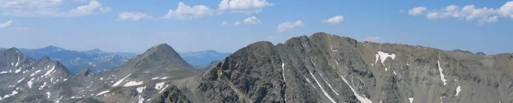
In an area full of rugged mountain landscapes, Missouri Mountain (4,290 m/ 14,074 ft) and its lofty neighbours propose both day-long summit ascents and multi-day loop treks. With trails criss-crossing this wilderness, you’ll be able to stare at mountains twice, as they get reflected in one of the many crystal clear lakes that line their bases.
Jump to Climbing or Hiking Guide.
With panoramic views from the top of Missouri Mountain, you’ll stare out at this sea of mountains stretching to the horizon in all directions in one of America’s greatest landscapes.
HISTORY OF MISSOURI MOUNTAIN
As is the common history across Colorado, the Ute people were the Native American population who lived near Missouri Mountain long before white European settlers arrived. Skilled hunters who lived in relationship with the landscape, they were also one of the first Native Americans to own horses, brought from the south in the early 1800s. Their presence in mountainous landscapes was left largely undisturbed until the mid-19th Century, when the land caught the attention of the recent arrivees.
When a treaty was signed in 1863 that terminated all Ute claims to mineral rights and lands in the San Luis Valley, it set a precedent for many other such treaties. In the following decades, Native Americans were moved off their lands to make way for the late 19th Century mining boom across Colorado.
It was from this boom that Missouri Mountain gained its name.
This Colorado mountain was named by miners who travelled west from Missouri to the area in the early days of 1880s silver mining rush. Roaming the valley to the north of Missouri Mountain, known as Clear Creek, they had arrived to dig their riches from the ground that in time produced gold, silver, lead and other metals.
- Browse a list of books about the Colorado 14ers
- Read our profile of the Colorado 14ers
- Read our profile of The Rockies
They named it to display a fondness, and perhaps longing, for the folks back home. As the etymology of the name Missouri is the ‘town of large canoes’, it is unlikely they saw a direct resemblance of the area to their home city.
This was a rich area for prospecting. Nearby Leadville, a little to the north, was the largest silver-producing district in Colorado from the late 19th to mid-20th Century. As States, Colorado and Nevada have both nicknamed themselves the ‘Silver State’ in the past, though Idaho has actually produced more than both of them.
The same miners that named the mountain are also credited with naming Missouri Gulch and Missouri Basin. Perhaps this was where they came to get away from the slog of digging, or perhaps it was a shrewd move to prospect other sites as theirs got busy or the minerals ran out.
The name Sawatch, the range Missouri Mountain is part of, is a Ute word meaning ‘waters of the blue earth’. This name refers to the ‘sea’ of mountains that make up this range, something you can enjoy with panoramic views from the summit of Missouri.
The sub-range known as the Collegiate Peaks that Missouri Mountain stand in contains five peaks named after elite US and UK universities. These include Mount Oxford (4,316 m/ 14,160 ft) and Mount Princeton (4,329 m/ 14,204 ft). These peaks gained their college associations between 1869 (Mounts Harvard and Yale) and 1925, when the Collegiate Peaks came to be known as a defined group.
Naming mountains after elitist universities isn’t to everyone’s taste, however. This article argues such naming counters the “founding mythology of the United States”. At the time of writing, there are no plans published for any changes of names, so the protest must still be relatively small.
GEOGRAPHY OF MISSOURI MOUNTAIN
The 160 km (100-mile) long Sawatch Range contains some of central USA’s most rugged scenery. With 15 of Colorado’s 14ers, the highest concentration in the US, and 8 of the 20 highest peaks in the Rockies, it is a mighty chain to be part of.
The Continental Divide, which runs south-east to north-west across the whole continent, runs close by Missouri Mountain. This mountainous and hydrological divide of east and west USA is a spectacular wilderness area, as well as a fault with significant mountain building history. Around 64.5 km (40 miles) of it runs through the west of the Collegiate Peaks Wilderness Area (see below).
Many peaks in the area bare the scars of human endeavour. The silver, lead, gold and other metals that this ground was once rich in led to huge swathes of countryside being mined. Most activity ended in the 1960s, by which time the landscape had been effectively plundered of what we deem valuable. Deep man-made indentations can be seen around the Missouri Mountain area, though most are slowly being reclaimed by nature.
Collegiate Peaks and Wilderness Area
Missouri Mountain resides in the Central Sawatch Range and, within this, is part of the Collegiate Peaks.
With Mount Harvard (4,397 m/ 14,427 ft) as its high point, this square sub-range of peaks stretches 55 km (34 miles) west-east and 48 km (30 miles) north-south. Missouri Mountain is the eighth highest peak in this group of 19 mountains.
Nearest to Missouri Mountain is Mount Belford (4,329 m/ 14,203 ft), found to the east across Elkhead Pass (4,029 m/ 13,220 ft). Mount Oxford (north-east) is part of the same ridgeline, while Mount Harvard (to the south-east) is another near neighbour.
Most of the range can be viewed at distance by car, visible from the Collegiate Peaks Scenic Byway that runs from Granite in the north to Poncha Springs in the south.
Strangely, the Collegiate Peaks also contain several mountains called Grizzly Peak and one called Grizzly Mountain. The highest is 4,266m (13,995 ft) in the Sawatch Range, and the shortest is 4,048 m (13,281 ft). This is a popular North American mountain name, with others in California and Alberta.
The Collegiate Peaks Wilderness, a protected area that surrounds these mountains, contains over 160 km (100 miles) of defined hiking trails. It was designated in 1980 and today covers parts of the Gunnison, White River, and the Pike and San Isabel National Forests.
It has the highest average elevation of all wilderness areas in the contiguous United States.
Rivers
This area is also important as a watershed for three rivers: the Gunnison River and the Roaring Fork River feed west into the Colorado River. The upper Arkansas River, which is the first part of the 2,364 km (1,469 mile) long river that, eventually, feeds into the Mississippi, begins in these mountains.
WILDLIFE OF MISSOURI MOUNTAIN
Flora
Containing sections of three National Forests, Gunnison, White River and the Pike and San Isabel Forests, Missouri Mountain’s vegetation is typical of the area.
In lower elevations, such as in the valley near the main trailhead, lodgepole pine, interspersed with juniper and aspen, makes up much of the forest population. Climbing higher, Englemann spruce and subalpine firs take over.
Once on the mountain, tree life all but disappears, replaced with broken up barren rock and the occasional krummholz (stunted and deformed) tree.
Grassland and alpine meadows also cover the area, where high grasses are littered with wildflowers of all colours. Come spring, these meadows are stunning places to slow your hike down and breath in the scenery under the constant gaze of the mountains.
Alpine fireweed, subalpine valerian and scarlet paintbrush are just a few of the species that light up these meadows. Subalpine valerian is a delicate white-flowering plant found in the higher elevation meadows around Missouri Mountain.
Meanwhile, tucked between rocks left undisturbed long enough, alpine sorrel, rock senecio/ragwort and sky pilot can be a reward for the careful spotter. From black to yellow to sky blue, these plants are a welcome breaking up of the sea of light grey in which they attempt to flourish.
Fauna.
With their small back-curving horns, mountain goats can be found on the craggy slopes of Missouri Mountain and its neighbouring peaks. Living almost exclusively above the tree line, these mountain climbers can be seen clambering across the terrain with an ease we could only dream of.
Yellow-bellied marmots, a type of large squirrel, can be seen scampering among the forested areas while the diminutve pikas live higher on the slopes. Both hibernate through the winter, marmots from September to April, and spend much of the rest of the year building a warm den and putting on weight ready for the following winter.
You’ll be more likely to meet a marmot than a pika up close on the trail, especially if you’ve an open packet of biscuits in your bag. Referred to as a “pig” by locals, marmots will happily scavenge food from human visitors. Although not encouraged, they are at least decidedly less threatening than having that other known scavenger, the black bear, wander in to your campsite.
Elk and moose are found in the wet valleys and lower slopes while bighorn sheep join the smaller-horned goats up on the slopes. Predators range in size, from mountain lions and lynx to bobcats and pine martens. Only the black bears are animals to be particularly cautious with, though even they will avoid human contact most of the time.
FIRST ASCENT OF MISSOURI MOUNTAIN
There are no records of the first ascent of Missouri Mountain. Not being a particularly difficult climb, the first ascent is often credited to the miners who named the mountain, though no clear proof of this, or a date for the ascent, can be found.
CLIMBING GUIDE FOR MISSOURI MOUNTAIN
Start early and avoid the storms. This is the general advice for hiking in this area, where summer lightning storms have been known to not only ruin a day’s hiking but have even proved fatal. Two climbers died after being struck by lightning in Colorado in 2003, so any threat of it (usually in the afternoons) should be taken very seriously.
The Missouri Mountain Trail or North-west Ridge Route (16.5 km/ 10.2 mile return) heads along the Missouri Gulch, approaching the mountain from the north. The trailhead (2,951 m/ 9,681 ft) is used for ascents of Mount Bedford and Mount Oxford too and is found near the settlement of Vicksburg.
It is considered moderately difficult at class II, largely because of the steepness of the switchbacks and the scrambling required near the summit. There are variants that can make it up to class IV, though they are less frequently taken.
The first section of the hike through forest and the penultimate section where you gain the summit ridgeline, consist of steep switchbacks. In between is a steady trek up the grasslands of the Missouri Gulch.
You follow the same approach for all three peaks until they split off during the hike up the gulch. Keep to the trail that heads to the right as Mounts Oxford and Belford are to your left.
Eventually the trail turns towards Elkhead Pass, and at this point you’ll begin to climb the second set of steep switchbacks. After these switchbacks (alternatively just head straight up the green grass and scree slope) you gain the summit ridge to the north-west of the summit.
The final section demands some scrambling during the traverse to the summit. This section is deceptively steep, though there’s only one section steep enough to really pose a challenge.
By the summit, 1,339 m (4,393 ft) has been gained, along with panoramic views of the sea of mountains all around. This includes the State’s highpoint, Mount Elbert (4,401 m/ 14,440 ft) off in the distance, with Mount Bedford and Mount Oxford just over the Missouri Gulch.
A popular climbing challenge is found in the North Face Couloirs Route. While still only rated class III, it involves around 375 m (1,230 ft) of vertical distance to climb over 45º climbing walls, often consisting of both rock and snow.
The approach is as per the route above, but at the point the route detours up to Elkhead Pass, instead head directly to the easternmost couloir, which should be due south. The climb begins at 3,871 m (12,700 ft), scaling four consecutive snow couloirs which get more difficult as you go.
The last couloir leads you to a high point of 4,246 m (13,930 ft), after which you backtrack along the ridge to the summit. Descent via the simpler North-west Ridge is recommended.
The Elkhead Pass, which sits between the Missouri and Bedford mountains, is used as a centre point by those wishing to bag all three peaks on one trip. This is possible to achieve in one very long day, and entails 2,256 m (7,400 ft) of elevation gain over 23.5 km (14.5 miles).
INFORMATION ON TREKKING AROUND MISSOURI MOUNTAIN
Within the giants of the Sawatch Range is some of the best hiking in central USA. From aspen and pine forests in the valleys, wildflowers above the tree line and waterfalls, lakes and high mountain passes, the possibilities for hiking here are, almost, endless.
Although not great for technical climbers, the range is ideal for hikers with its steep approaches but no more than gentle climbing challenges. Most routes are more than a walk-up but less than a climb.
For solitude, one of the best spots to head to is the Hunter-Fryingpan Wilderness. Laced with high altitude streams, it is less frequented than other areas in the central Sawatch Range possibly because its mountains are lower than neighbouring wildernesses.
Popular trails criss-cross the Collegiate Peaks Wilderness Area. One way to experience the area as a whole is to take on the 11-day, 257.5 km (160-mile) trail called The Collegiate Peaks Loop.
- Browse a list of books about the Colorado 14ers
- Top Long-Distance Hikes in US & Canada.
- What to take on a hike?
Following sections of the Colorado and Continental Divide Trails, the loop can be begun at any of the trailheads found on the route. If walking clockwise, it is recommended to head along the Colorado Trail East first, which has lower elevations and is used as the traditional thru-route for for the Colorado Trail, which crosses the whole State.
The higher and more rugged Colorado Trail West, a relatively new addition and preferred route for the Continental Divide Trail, provides more impressive views, though the hiking is tougher on the whole. Best taken second when packs are lighter and bodies are into the swing of long distance hiking.
Aside from this long excursion and the summit trails full of hikers heading off to bag another 14er peak, there are plenty of shorter day-hikes or overnight trails in this wilderness.
The Kroenke Lake Trail is a 13 km (8.2 mile), moderately challenging trail that ranks highly. It has the option of a 5 km (3-mile round trip) extension to gain Brown’s Pass, which offers stunning views of the surrounding peaks.
Many choose to hike to the lake and camp overnight, such is the beauty of the scenery, but don’t go expecting backcountry solitude. In peak season, it is unlikely that you will have been the only one to have this bright idea